Architectural History
If you come to Boston expecting to see a city full of buildings that date back to Colonial America, you will probably be disappointed. While there are a few surviving examples of traditional New England architecture—salt box houses with small windows and wooden clapboards—like most U.S. cities, Boston has had several face lifts over the years. And now, with the completion of the Big Dig and the removal of its old elevated highway Central Artery, it’s in the midst of yet another.
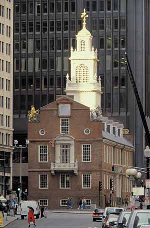
Photo courtesy Greater Boston CVB/ FayFoto
The Old State House, built in 1713—and decommissioned in 1798—it was here that the Declaration of Independence was first read publicly in Massachusetts on July 18, 1776.
Boston’s oldest neighborhoods are downtown and the North End. These harbor-front areas are where you’ll find Paul Revere’s house—an archetypal New England Colonial dwelling—as well as the city’s earliest churches and meeting houses. The North End, with its smaller scale and winding narrow streets, feels European. Downtown, by contrast, is Boston’s Financial District and full of skyscrapers—although you’ll spot one or two Colonial hold-outs.
Following the War of Independence, Boston’s first major expansion—and the emergence of a vernacular architectural style—occurred in Beacon Hill. Located to the west of downtown on a hill, as well as land reclaimed from Boston’s Bay Bay, this area was home to the city’s African American community. Around the turn of the 19th century, as developers bought up farmland to convert it into upscale houses, architect Charles Bulfinch defined the Federalist style—a Georgian take on neoclassicism sporting plenty of red brick—with buildings such as the Massachusetts State House and three different houses for politician Harrison Gray Otis.
During the mid-1800s, more of Back Bay was filled in to the west of Beacon Hill to create a neighborhood of the same name (Back Bay). The major east-west streets were laid out in a grid pattern, while north-south cross streets progressed alphabetically; all were lined with elegant brownstone mansions. Copley Square, at the neighborhood’s core, became home to two of the 19th century’s architectural masterpieces: Trinity Church and the Boston Public Library.
Boston’s South End was also developed during the latter half of the 19th century. Here the streets became wider to accommodate streetcar lines, and the houses, while many of them were brownstones, included a more eclectic architectural mix typical of the Victorian era.
Perhaps the most important development of the 19th century was a system of linked parks called the Emerald Necklace, laid out by the great landscape architect Frederick Law Olmsted. The green chain stretches from Boston Common and the Public Garden, in the heart of Back Bay, west along the Fenway into Brookline, and then culminates with the massive, 527-acre Franklin Park in a suburb to the south of Boston.
Beginning in the 1940s, Boston’s northern neighbor Cambridge, Massachusetts, became a hotbed for architecture in the Modernist, International, and Brutalist styles. During that time, the influential architect Walter Gropius and his protégé Marcel Breuer left Europe and came to teach at Harvard University. Gropius attracted a following and went on to found The Architects Collaborative, which designed several important buildings in the Boston area. Both Harvard and the Massachusetts Institute of Technology, meanwhile, undertook expansion plans and tapped these architects and other 20th century greats—including Alvar Aalto and Eero Saarinen—to design for their campuses.
But in many respects, the 20th century was unkind to Boston’s urban fabric. Planners rammed an elevated highway, Interstate-93, through the core of downtown, isolating the North End. Scollay Square, the city’s historic commercial and municipal government center, was razed and replaced with a lifeless, windswept plaza anchored by Boston’s Brutalist City Hall.
Adversity is often the seed of opportunity. Beginning in the early 1980s, Boston’s colossal Big Dig project replaced the elevated I-93 expressway with a 3.5-mile stretch of underground roadway. The project lasted two decades and, with a price tag at nearly $15 billion, became the most expensive road construction project in history. But with the demolition of the old highway, 27 acres of land were opened in the heart of downtown. Much of the space has been refurbished as the Rose Fitzgerald Kennedy Greenway, which officially opens in fall 2008, but in the future it could also be home to museums and other cultural buildings.
The Boston area is home once again to cutting-edge architecture. Diller Scofidio + Renfro’s iconic new building for the Institute of Contemporary Art opened on the South Boston waterfront in late 2006. And in Cambridge, Massachusetts, MIT sports a Frank Gehry creation: the Ray and Maria Stata Center, whose sloping walls never quite form a 90-degree vertical plane (sometimes to the chagrin of maintenance officials).


Post a comment to this article
Report Abusive Comment