


Chengdu
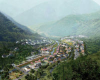
This master plan examines a study area along 37 kilometers of the Jin Jiang River and proposes important changes to the planning bureau's existing plan. Within the study area, 3 percent of the land currently is urbanized and 97 percent is rural. The bureau projects that urbanized land will increase to 62 percent and rural will decrease to 38 percent by 2020. The existing plan represents this urban growth as an unrelenting grid of superblocks extending from the city center out to a new 6th ring road, the new “boundary” between urbanized and rural areas. Johnson Fain's plan does not challenge the projected quantity of future urbanized land. What it does challenge, and proposes an alternative to, is the location and nature of this urbanization within the study area.
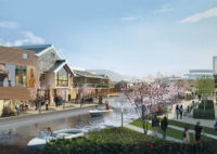
The new plan redirects the path of the projected urban growth to preserve the assets of the river valley and develop it into a valuable place for the region. William Fain and his team at Johnson Fain use infrastructure such as roads, rail, and sewer lines to guide urban growth to desired areas in the watershed and away from protected areas of the valley. To create a sustainable balance between these environments, the planners carefully weave urbanized and rural areas together, both economically and physically. The plan recommends an array of lifestyle and tourism-related land uses that can be implemented and developed within the study area to drive economic activity. Physically, the two environments are tied together by open-space systems that follow the watershed streams through the urban areas, and the river is made navigable to boating again with a series of low-impact fabric dams and locks, creating ports at the key towns and tourist destinations.
The new plan increases revenue and public utilization by providing for 65 percent growth in population and a balanced mix of land uses. Within the developed area, major developments are grouped at the intersections of primary roads, gradually stepping down in intensity in proportion to the distance from the centers. The least dense residential zone serves as a buffer between future development and the protected forest-farmland-riverfront zone. A primary consideration in the plan was determining the proper balance between lands for farming and those for natural preservation. The city's current plan provides for largely undifferentiated urbanization and the potential loss of approximately one-half of the existing farmland in the expansion area.
Johnson Fain's plan calls for locating schools, markets, financial services, and farmer co-ops within the rural area to encourage the farming population to stay on the land, using contemporary agricultural techniques to increase food production. The plan also proposes decentralized water- and waste-treatment infrastructure, including strategies such as “wastewater wetlands” that naturally clean runoff water as it returns to the river. The planners phase infrastrcture construction to keep pace with growth. By providing an appropriate balance between rural and urban development and accommodating modernize farming and environmental protection, the plan will improve the character and image of the city.
PeopleHeading - simply apply bold: Sub-heading - apply ital: |
ProductsHeading - simply apply bold: Sub-heading - apply ital: |
Post a comment to this article
Report Abusive Comment