Continuing Education: Urban Future
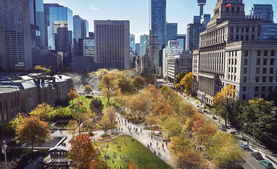
Image © PUBLIC WORK
Do you think you have the answer to why the chicken crossed the road? As city dwellers worldwide will now tell you, it wasn’t simply to get to the other side. No—that chicken crossed the road because the sidewalk wasn’t wide enough for social distancing in a pandemic. Geographer Daniel Rotsztain demonstrated that last spring in his viral video of collaborator Bobby Gadda trying to navigate in their home city with a 6-foot-radius hoop slung over his shoulders.
The current crisis has highlighted long-standing issues around the livability, safety, equity, and sustainability of streets, while placing new demands on residents, workers, and businesses as they tried to adapt to the spatial implications of the contagion. Cities around the globe responded with a speed unprecedented in peacetime, rolling out a range of adaptive measures. These include reallocating road lanes to extend the width of sidewalks and to provide bike and public-transit routes; improving the safety of crossings by using vertical elements and surface markings (as emptier streets have led to higher speeds, driving up pedestrian fatality rates); and increasing connectivity and mobility options with slow or shared street programs (where vehicle access is limited to local traffic at reduced speeds, and priority given to pedestrians and cyclists). Streets have been opened as space for physical activity, play, and distanced socializing; as outdoor classrooms, health-check zones, and drop-off areas for schools; and as expanded gathering space for cultural, religious, and civic institutions. Businesses have been permitted to use street space for outdoor dining, pickup and delivery, and markets. And special-event provisions have supported the exercise of fundamental civil rights, such as voting and protest.
Underlying these changes is a growing recognition that the street is not just a way of moving traffic around: it is the most significant publicly owned land asset that municipalities have for achieving civic goals. “We need to rethink for what and for whom our streets are put in service,” says Gia Biagi, transportation commissioner for the City of Chicago. “This pandemic has made it possible for Chicagoans to see that more clearly.”
Based on public outreach to better understand neighborhood needs, Chicago has implemented 125 blocks of shared streets and an outdoor dining program in which about 500 establishments are participating at 250 locations across the city. A focus on mobility justice has resulted in pop-up bus-only lanes, which have doubled transit service for some 20,000 essential workers, while also reducing fares. It has brought wider service on what is now the most geographically expansive bike-share program in the country, with the addition of e-bikes for longer distances, and an e-scooter pilot program in priority areas, based on equity, where high numbers of essential workers have faced mobility and connectivity challenges. “It’s a practice-oriented way of working that Covid has enabled, an open-mindedness to testing things,” says Biagi. “It’s local knowledge and local know-how that makes projects work and makes them stick.”
Urbanists see the coronavirus emergency as an extraordinary opportunity for the long-term transformation of streets in cities around the world. Examples from Toronto, New York, and Chicago address key themes that the pandemic has highlighted—including quality of life, mobility justice, and equity of access to public space. They demonstrate solutions that respond to local specifics, and illustrate changes that many city dwellers hope will be made permanent.
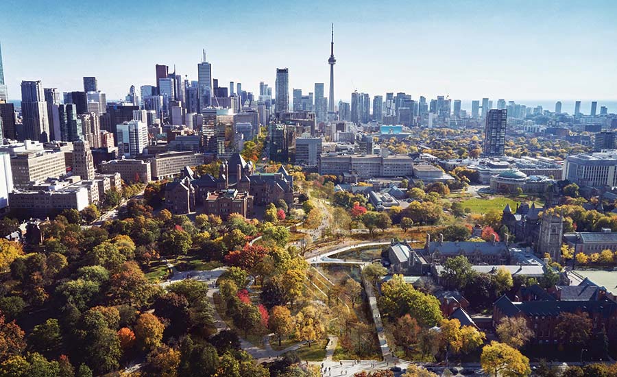
In Toronto’s core, one of the biggest issues is the lack of public open space. By the measure of the World Health Organization, green space per person falls far short of the minimum recommended 9 square meters—never mind the ideal of 50. During the short summer, thousands of Torontonians who wanted to be outside gathered unsafely in the downtown’s few small parks. With land for new ones scarce, “if city living is going to be relevant, competitive, and attractive post-Covid,” says Adam Nicklin, a principal at the local urban-design and landscape-architecture firm PUBLIC WORK, “you have to rethink the role of streets.”
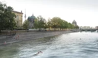
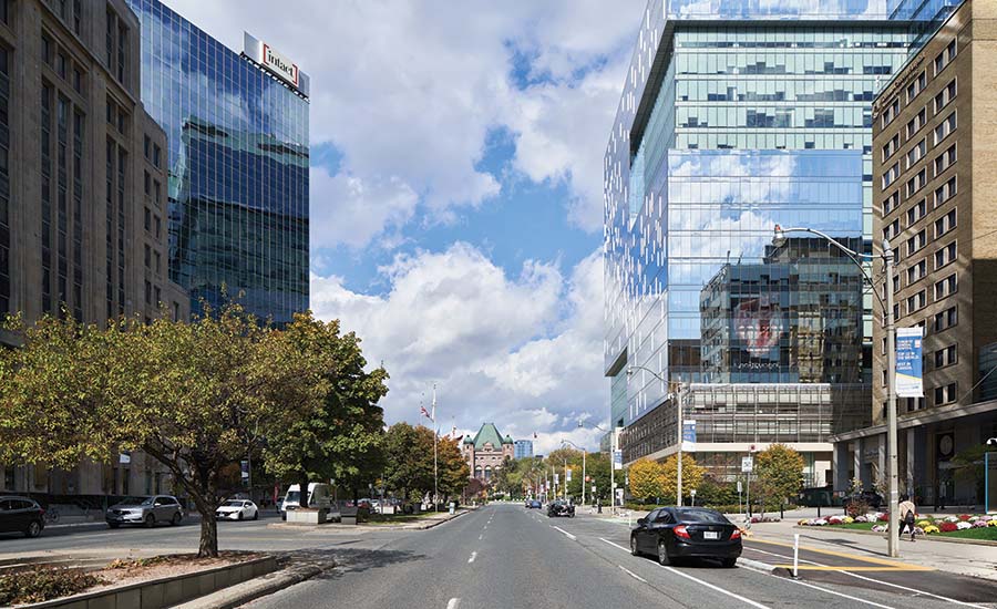
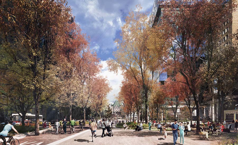
Isolated green spaces in Toronto, such as the one in front of the law courts (top), would be reimagined (above) under a plan by PUBLIC WORK for University Avenue. Photo © PUBLIC WORK, click to enlarge.
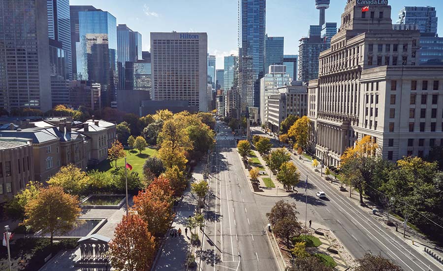
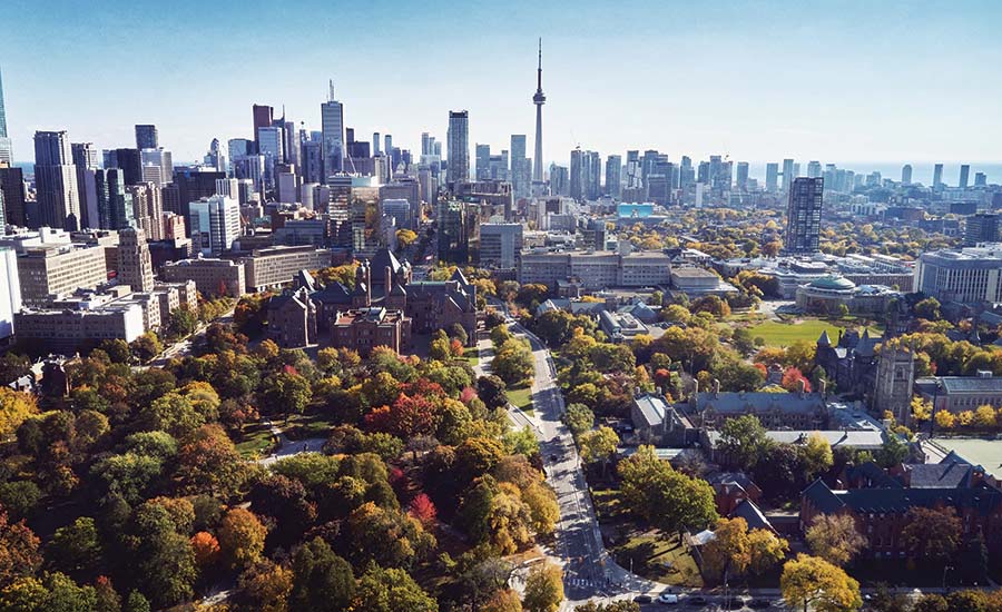
PUBLIC WORK has made a bold proposal, with sponsorship from the Michael Young Family Foundation and the urban-sustainability nonprofit Evergreen, to re-envision University Avenue, one of Toronto’s major north–south thoroughfares, as a civic promenade. The plan would consolidate six to eight lanes of vehicular traffic into four lanes on the western side, convert the eastern lanes to bike and pedestrian paths, and use ecological landscaping to link isolated patches of public green space along the route. The concept means taking just 9.5 acres of city-owned asphalt to create a 90-acre linear park. At its north end, the new University Park would connect the provincial parliament, the University of Toronto, and significant cultural institutions. Continuing south through the city’s hospital district, with much-needed places of green respite, it would pass the law courts and adjacent city hall, and finish at the shore of Lake Ontario.
Looking for quick answers on architecture and design topics?
Try Ask RECORD, our new smart AI search tool.
Ask RECORD →
The proposal also calls for the installation of green infrastructure to help mitigate the city’s increasingly severe flooding, and for the acknowledgement of indigenous landscape elements, such as a buried creek, in counterpoint to the colonial memorials that now dot the boulevard.
In addition to improving the quality of life in Toronto’s vertical neighborhoods, the project acknowledges the significance of University Avenue as the site for public protest and demonstration. “In this past year, more than ever before, we have realized the need for gathering places where people can raise their voice,” says Nina Pesavento, project lead for the Young foundation. With the provincial parliament and city hall, University Avenue is the street most symbolic of democracy in Toronto, Nicklin notes. Transforming it into a welcoming public space at the heart of the city, open to all, acknowledges the importance of street space in an equitable society.
1
2
3
4
The scheme for Toronto’s University Avenue would create a 90-acre linear park with Queen’s Park (existing, 1; proposed, 2) at one end and Lake Ontario at the other. It would connect civic and cultural institutions and pass through the hospital district (existing, 3; proposed, 4). Images © PUBLIC WORK
The proposal has attracted significant public and planning interest, and the mayor has recently convened a panel to study its feasibility. At a projected cost of just $215 million, and buildable in an estimated five years, in coordination with infrastructure upgrades scheduled to tear up the pavement in 2024 anyway, the project goes after low-hanging fruit, says Nicklin. “Instead of fragmented and disparate little pockets of unrelated land, you have—yes, a street—but also a massive civic park, a ceremonial space, a gathering place, a health district,” he says. “And it doesn’t have any magic tricks up its sleeve, other than just taking what you have and changing the way it works.”
A similar approach underlies a grand vision for Manhattan based on the superblock concept that Barcelona has been pioneering to wide acclaim. Not to be confused with the disconnected and monolithic superblocks of the mid-20th century that Jane Jacobs decried in The Death and Life of Great American Cities, the Barcelona model creates nine-block squares of traffic-calmed and shared streets, with transit connections and through-traffic at the perimeters. In 2016, WXY Architecture + Urban Design floated an idea for how the concept might be adapted for 30 or so blocks in New York’s financial district; in 2018, designers at Perkins Eastman made a case for applying the idea to the Manhattan grid more broadly. Most recently, WXY’s extrapolations from the city’s swiftly implemented pandemic programs, such as Open Streets and Open Restaurants, have led them to consider longer-term objectives—including climate response, equity, and traffic safety, as well as public health—and reintroduce the superblock concept.
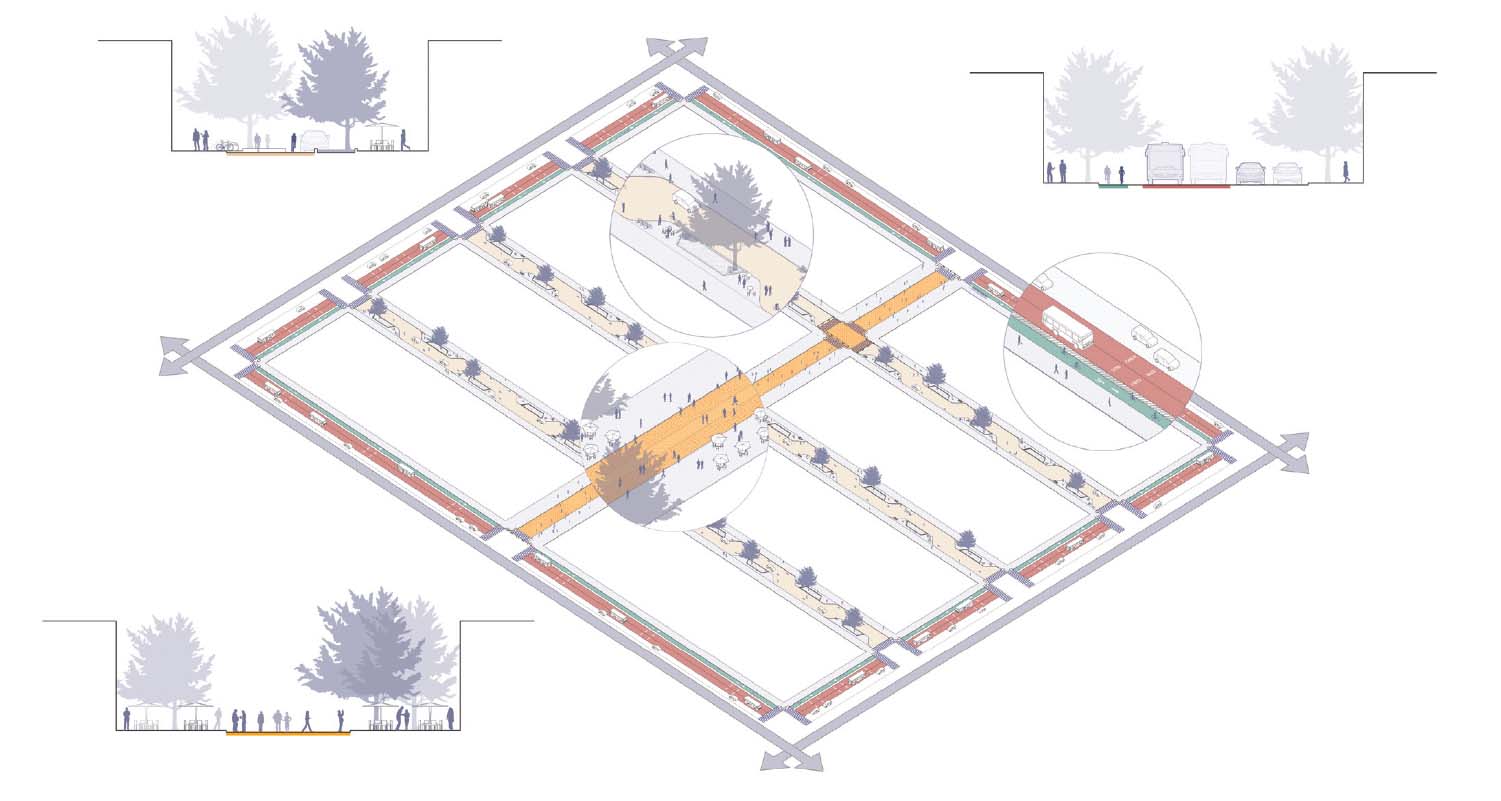
The superblock concept that WXY has put forward for Manhattan is based on an eight-block grid. Interior streets would be limited to local traffic, with a central spine for pedestrians. Image courtesy WXY
Taking the Manhattan core as a starting point, and referencing planning initiatives such as New York’s 2019 Streets Master Plan legislation, as well as analyzing existing and planned pedestrian, cycling, and transit networks, the proposal envisions a network of superblock modules, each consisting of eight Manhattan blocks. As in Barcelona, through-traffic is held to the perimeter, where dedicated bus- and bikeways enhance connectivity. Interior streets are designed as slow streets where vehicle access is limited to local traffic, with the central interior roadway becoming a pedestrian zone that serves as more of a front yard, similar to the Dutch woonerf, or living street. “The superblock model is attractive both for transportation and for creating a community within the grid,” says David Vega-Barachowitz, director of urban design at WXY. He sees the proposal as setting the table for the city administration to think big over the next decade about reallocating street space for more diverse uses, and turning the piecemeal, bottom-up initiatives of the summer of 2020 into a coherent transformation that advances the city’s long-standing goals.
Experience with unrelated temporary street modifications during the pandemic can help inform the phased rollout of a more comprehensive plan. One of the most significant insights to emerge from a WXY initiative—to create a series of parklets, curbside activations, and covered structures along the sidewalk of Strivers Row in Harlem—pertains to the process of designing, constructing, and operating a project that’s relevant and meaningful to the community, says Vega-Barachowitz. “Neighborhood partners play a critical role, not just in creating a design vision and an ideal spatial hierarchy, but in creating the place,” he says. While that experience shows that success depends on strong local organizations to helm the process and follow through, it raises the need to ensure that a lack of such organizational capacity to maintain public space does not become a barrier to equitable distribution of such desirable new spaces throughout the city.
WXY is continuing to develop the superblock proposal in collaboration with Sam Schwartz Engineering, and is working with advocacy partners to disseminate the vision to stakeholders across the city. With a new Department of Transportation (DOT) commissioner for the municipality and strong New York representation at the federal DOT, Vega-Barachowitz says the group sees a strategic opportunity to accelerate this kind of vision and to realize pilots and capital projects that will further its goals.
One of the central challenges of transforming a streetscape entails balancing the needs of multiple users and functions in a limited road-width. Designing for the ability to serve different uses at different times can help optimize streets and enhance their value to the community. For example, a curbside lane might serve as a dedicated busway during morning rush hours, become a midday greenway (with adjacent rain or community gardens) to facilitate neighborhood connections to parks or waterfronts via bike and other micro-mobility modes, and combine with adjacent lanes in the evenings or on weekends to allow for outdoor eating, recreation, or festivals.
An emerging concept supporting this type of flexibility is the modular lane, says Francesco Cerroni, mobility leader at Buro Happold, where the idea is being developed. Modular lanes use low-tech solutions like pavement markings and colored paint, along with medium-tech tactics including pavement-embedded lighting and hydraulic bollards. Innovations such as internet-connected sensors and smart curbs (where technology can enhance the varied and efficient use of in-demand zones) can also contribute. Such designation and information strategies, all of which now exist in various stages of use, allow modular lanes to be activated on demand, and modified with the season, day, or hour. “With good management of these elements,” says Cerroni, “we can create a successful story for redistributing and reusing the street space.”
As the technology of transportation advances, experts widely agree that it should be employed to facilitate good design rather than vice versa. SOM and the technology-based innovation nonprofit City Tech Collaborative recently teamed up to develop a set of ideas, with input from multiple stakeholders, on how streets in Chicago could evolve over the next 10 to 30 years. Design concepts, modeled on that city’s typical street types, take account of new technologies such as access to real-time information on personal devices about transit service and on-demand cars; innovations in equipment, like autonomous vehicles and faster telecommunications; mobility trends, including electrification and the rise of micro-transit; and functional priorities: freight and logistics, public transit, personal vehicles, cycling, and walking. Arising from these considerations come a set of predictions, strategies, components, and case studies for tailoring solutions to neighborhood conditions. While the study doesn’t take Covid into account explicitly, “resilience depends on flexibility and adaptability, which are relevant to a pandemic as well as other stressors,” says Christopher Hall, urban-strategy leader in SOM’s City Design Practice.
5
6
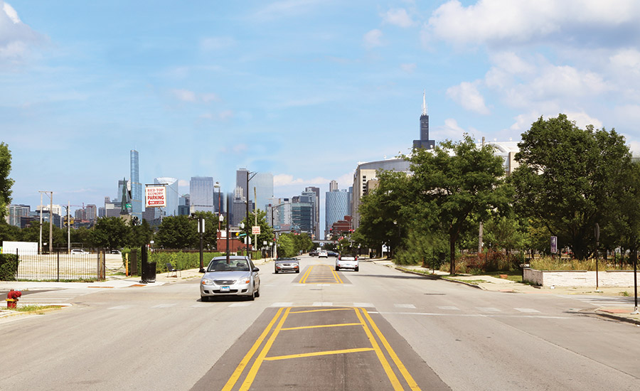
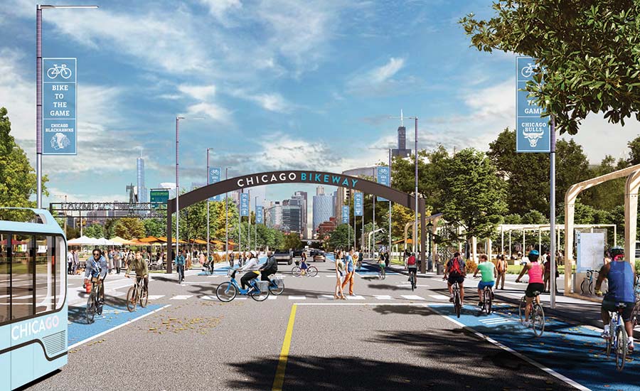
For Chicago, SOM and City Tech Collaborative propose transforming Chicago’s roadways, including Madison Street, on the West Side, from multi-lane arteries for cars (5) into space that could better accommodate cyclists, pedestrians, and public transit (6). Images courtesy SOM
Besides the future function of Chicago’s streets, SOM is also considering the city as a whole. Looking at mapping and overlays of the greenways and boulevards that were part of Daniel Burnham’s influential 1909 Plan of Chicago (which was only partially implemented), “you start to see a green weave emerge that could put everyone in Chicago within a five- to ten-minute bike ride of a park,” says Doug Voigt, head of SOM’s City Design Practice. Using the city’s boulevards and abandoned rail lines this way could quickly mitigate Chicago’s inequities around access to green space and build on the city’s pandemic responses by adding connections to its centralized, radial mobility network. The “green weave” would also incorporate stormwater management and improved habitat, adding further value to the public realm.
These ideas are influencing government decisions regarding ongoing city-led rail and trail initiatives, as well as the use and quality of streets as public spaces in response to the pandemic, Hall and Voigt say. The research is also expected to inform discussions about how anticipated federal infrastructure funding could be used to develop Chicago’s streets.
During Covid-19, street changes have happened fast, and they’ve provided momentum for long-term change. Significant proposals like the ones from Toronto, New York, and Chicago are raising awareness of fresh possibilities and priorities for underserved neighborhoods. “The pandemic has brought to the fore the appreciation and understanding of how important our streets are to the livability of our communities,” says Hall. All of which makes this an exciting time in the history of streets—and for anyone with a reason for crossing them.
Continuing Education

To earn one AIA learning unit (LU), including one hour of health, safety, and welfare (HSW) credit, read the article above and Streets for Pandemic Response & Recovery, NACTO and Global Designing Cities Initiative (PDF).
Then complete the quiz. Upon passing the test, you will receive a certificate of completion, and your credit will be automatically reported to the AIA. Additional information regarding credit-reporting and continuing-education requirements can be found at continuingeducation.bnpmedia.com.
Learning Objectives
- Explain how Covid-19 is prompting cities to consider the reconfiguration of street space as a means to accomplish civic goals.
- Describe how urban streets can be revamped to advance goals for equity, mobility, and climate.
- Discuss street adaptations that could help cities improve green-space access.
- Describe emerging digital technologies that could help cities better manage their streets and promote a diversity of uses.
AIA/CES Course #K2103A
Looking for a reprint of this article?
From high-res PDFs to custom plaques, order your copy today!