Going with the Flow
From coast to coast, design professionals deploy innovative strategies to manage water and enhance sustainability.

Going with the Flow
These stepped plazas in Rotterdam have been intentionally designed to flood when it rains heavily. During dry weather, they provide space for recreational activities, including basketball and skateboarding.
Greening the East River
In New York, two new community parks along the East River serve as case studies in water management and in making coastal areas resilient.
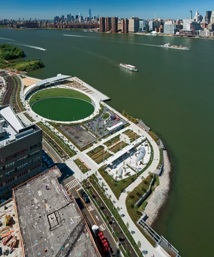
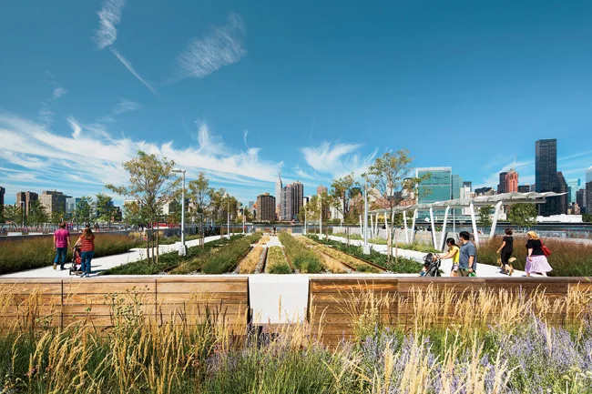
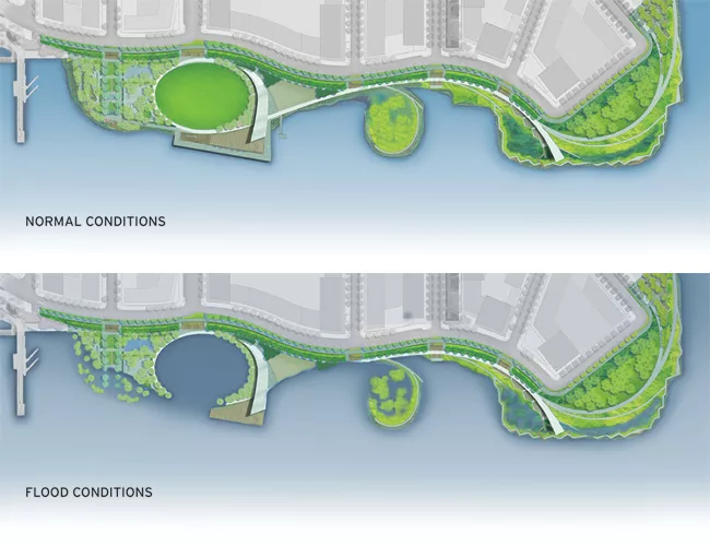
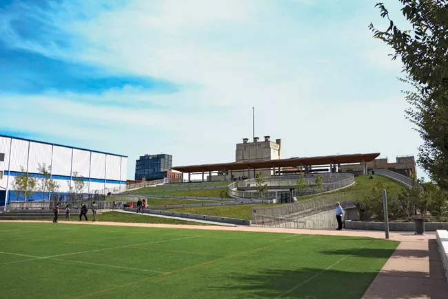
Looking at the Hunter's Point South Waterfront Park in Queens on a sunny day, with children playing on its elliptical sports field and people lounging on its benches or seeking shade under the delicate arcing pavilion that flares toward the Manhattan skyline, one might never suspect it was built with a torrential downpour in mind. But the 11-acre park, designed by Balsley's firm and architects Weiss/Manfredi, incorporates several strategies aimed at helping manage the runoff created during such storms. It includes elements such as permeable paving and bioswales (planted channels that slow, filter, and infiltrate stormwater flows).
The primary goal of this so-called “green infrastructure” is to keep runoff out of the city's sewer system, explains Gillian Blake, a principal at the engineering firm Arup, the project's prime consultant and its infrastructure designer. This function is critical, because New York has a combined sewer system—one that carries both stormwater and sewage together, in the same pipe. Under dry conditions, the contents of the combined sewer are carried to a treatment facility. But heavy rainfall can easily overload the system, and, in those instances, the runoff-sewage mix is dumped directly into the city's waterways, untreated.
The park also has features that help it weather the effects of the East River's overflowing its banks during a storm surge like the one caused by the 2012 “superstorm,” Hurricane Sandy. But instead of creating artificial barriers to prevent such incursions, the team decided to let areas like the playing field flood. Since the salt water of the East River (which is actually a tidal strait) can damage vegetation and be corrosive to buildings and infrastructure, it was important to grade the park's terrain so that the storm surge would flow easily back to the river rather than to the overburdened sewers. Other areas that would collect water, such as the bioswales, were designed to help it percolate into the ground quickly. They were also planted with hardy native vegetation that can withstand occasional doses of salt water, explains Balsley.
This “catch and release” approach is more akin to the way nature buffers costal areas and helps protect upland communities, says Marion Weiss, Weiss/Manfredi principal. “We try to bring natural systems and infrastructure closer together,” she explains.
The park at Hunter's Point South, which officially opened in August 2013, was approaching completion when Sandy's surge washed over it and put the design to the test. After the waters receded, there was no significant damage to the park's structures or landscape.
Tough Turf
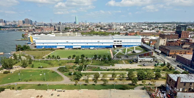
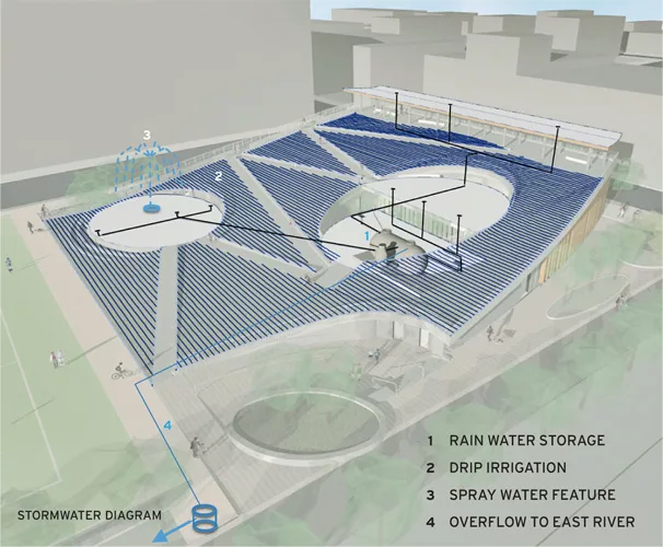
Just to the south of Queens, Bushwick Inlet Park, designed by Kiss+Cathcart Architects, and Starr Whitehouse Landscape Architects, is part of an ongoing transformation of a formerly gritty section of the Brooklyn waterfront. Conceived as a blanket of greenery that folds up to cover the roof of a wedge-shaped community building, the three-acre site includes parkland at the water's edge and a playing field.
Sitting on top of a capped brownfield that was most recently a parking lot, the site's longitudinal section works on a number of levels to manage stormwater and ensure that no runoff is directed to the city's combined sewer system. The building meets the street with a glass and concrete facade, its roof sloping down to converge with the site at the playing field and finally descending to the river. The planted roof absorbs some of the flow of stormwater, and then an area of gravel fill under the playing field detains it while it infiltrates the ground. Any surface runoff that reaches the river is first filtered through a swath of native plants at the river's edge.
“Extensive” green roofs—those designed with just a few inches of growing medium and not intended for foot traffic—typically don't require much maintenance or irrigation. However, Bushwick's “intensive” green roof, which also acts as a grandstand, has a foot of topsoil and requires some irrigation. Toward that end, a portion of the site's stormwater is captured and used as a resource: along with graywater from a playground fountain, it is stored in a 15,000-gallon tank that supplies the roof's underground drip irrigation system.
And like Hunter's Point South, the nearly complete project was inundated with salt water when Sandy struck. Water came about 80 feet onto the site, then receded with no real damage to the landscape, according to Stephen Whitehouse, Starr Whitehouse principal. Since the building was located away from the water on the street edge, it was well out of harm's way.
Water in the West
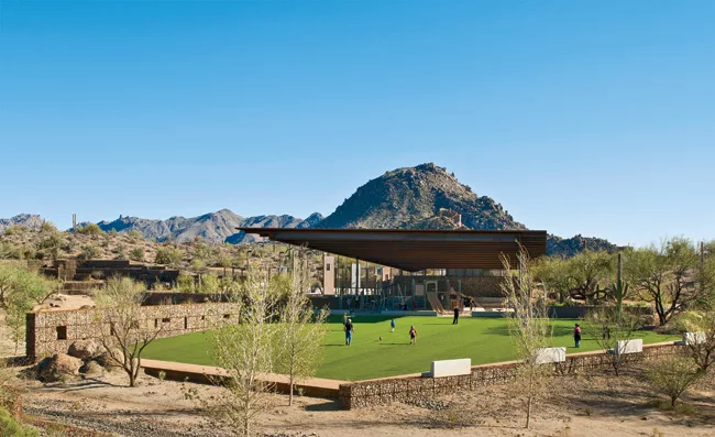
Although Arizona's arid Maricopa County gets a mere 7 inches of precipitation a year, when it rains there, it often falls in torrents. In conceiving the George “Doc” Cavalliere Park in Scottsdale, planners envisioned a precedent-setting facility that would help manage this stormwater while relying primarily on green infrastructure elements. Due to these strategies, when the park was completed in 2012, it earned three out of a possible four stars from the Sustainable Sites Initiative (SITES), a LEED-like rating system for landscapes. At the time, it was the highest SITES rating any project had earned.
The park's location was a challenging one because it sits at the confluence of two seasonal stormwater “washes.” This condition required that designers from the landscape architecture firm Floor Associates integrate detention for a volume of water equal to nearly 50 acre feet into the design (one acre foot is equivalent to an area 66 feet by 660 feet by 1 foot deep).
|
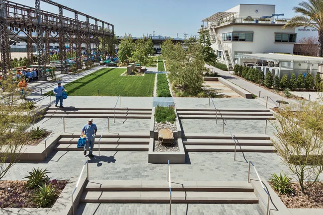
Ponds with a Purpose Bioswales, vegetated detention ponds, or other devices that mimic natural processes, are not the only ways to slow the flow of water into the landscape. The Dutch, who have a long history of managing water systems, are exploring a different approach, especially for intensively used urban spaces that call for hardscape ground surfaces. The Benthemplein Water Plaza, a pilot project in Rotterdam, is one such environment. It is designed to capture stormwater by allowing recessed paved areas for socializing and recreation to flood during heavy rainfall. Since portions of the city have a combined sewer system, just like New York's, one goal of the project is to mitigate the impact of runoff on existing stormwater infrastructure. But the plaza is also designed to celebrate water, says architect Florian Boer, founder of the local firm De Urbanisten. Stainless-steel troughs wind through the plaza and during downpours send water cascading into stepped concrete basins. Because local health regulations stipulate that standing water be drained within 36 hours, the system is designed to send water to smaller basins that gradually filter runoff, through infiltration, into the water table. A larger basin, which collects runoff from the surrounding area, employs pumps to direct water to nearby canals once these waterways have receded sufficiently.
|
They satisfied this requirement by locating playing fields and a pavilion in a natural depression and allowing the area to flood during extreme downpours. This part of the site acts as a detention basin that temporarily holds the water, then releases it to a lower basin and, ultimately, into the area's drainage system. Because local health regulations, similar to those in place in other jurisdictions (see sidebar above), limit how long standing water can be contained, the site and its soils are engineered so that water drains within 36 hours.
The slopes above the basin are laced with staggered gabion walls that slow stormwater sheet flow and form small catchment areas, fostering desert vegetation. A primary advantage of using these native plantings is that, once established, they don't require irrigation and need little maintenance. “Maintenance is an aspect of sustainability that is often overlooked,” says Chris Brown, a Floor Associates partner. Similarly, the project's palette of architectural materials—weathering steel, local stone, and concrete—requires little upkeep.
The project also includes a permeable paving material made from site-salvaged decomposed granite, a granular ground cover that's a common feature of the desert surface. The decomposed granite is stabilized with a liquid co-polymer and then compacted, but remains permeable to stormwater runoff. It also helps combat the heat island effect. A stabilized-granite parking lot, for example, can feel 20 degrees cooler than an asphalt-paved lot, says Brown.
Water and Power
With its so-called “Mediterranean” climate—one distinguished by warm, wet winters and hot, dry summers—the Los Angeles basin gets twice as much rainfall as central Arizona. But, because of the enormous population and lack of nearby reservoirs, water management in the Los Angeles region is just as critical.
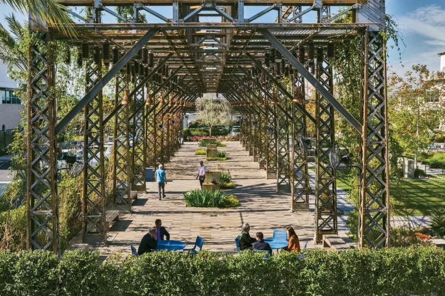
Since 2008, the utility Burbank Water and Power has been involved in transforming its Magnolia Power Plant into an “ecocampus” highlighting water management. “The idea was to turn an industrial complex into a garden,” says Evan Mather, a principal at AHBE: Landscape Architects. The firm's vision included interpreting and restoring a woodland and riparian environment in an industrial context, he says.
The most recent addition to the campus is the Centennial Courtyard, a decommissioned substation that AHBE transformed into an outdoor dining area sheltered by a vine-covered trellis. The project received SITES accreditation in 2012.
The centerpiece of the ecocampus stormwater management system is an old utility tunnel that designers converted into a filtration trench. The surface water and that of an adjacent building's green roof is fed into this trench, which is filled with gravel salvaged from the site and topped with plants that harmlessly absorb toxins from the runoff through a process called phytoextraction.
In addition, the designers incorporated tree bio-filter boxes. These devices embed a tree's roots in a stormwater catchment basin to help filter pollutants that can accumulate in stormwater from cars, refuse, and other sources. The design team also used pavers supported with a modular rigid frame. The system provides a permeable surface while preventing soil compaction, so that tree roots can spread.
Plantings are mostly native and do not require irrigation. But those that do need irrigation rely on wastewater treated and reclaimed from the power plant's operations, including its generators and its cooling towers. That saves up to 100,000 gallons of potable water a day.
The Burbank Water and Power project, and the new parks in Scottsdale and New York, demonstrate that green infrastructure can play critical water-management roles in diverse settings and climates. These projects showcase strategies that could help communities become more sustainable and resilient in the face of disaster.
People |
Products |
Looking for a reprint of this article?
From high-res PDFs to custom plaques, order your copy today!


