Continuing Education: Designing for Coastal Resilience
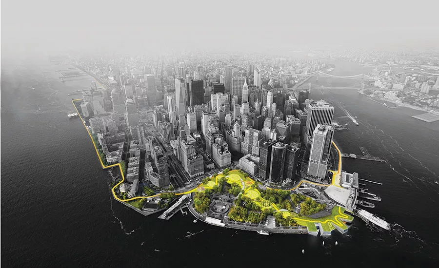
The Big U will wrap the southern tip of Manhattan and combine hard, heavily engineered infrastructure with softer protection devices, and include parkland and other social and recreational amenities.
Rendering courtesy Bjarke Ingels Group
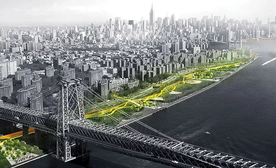
The first phase of the Big U will stretch down the East Side of Manhattan from 25th Street to south of the Williamsburg Bridge.
Rendering courtesy Bjarke Ingels Group
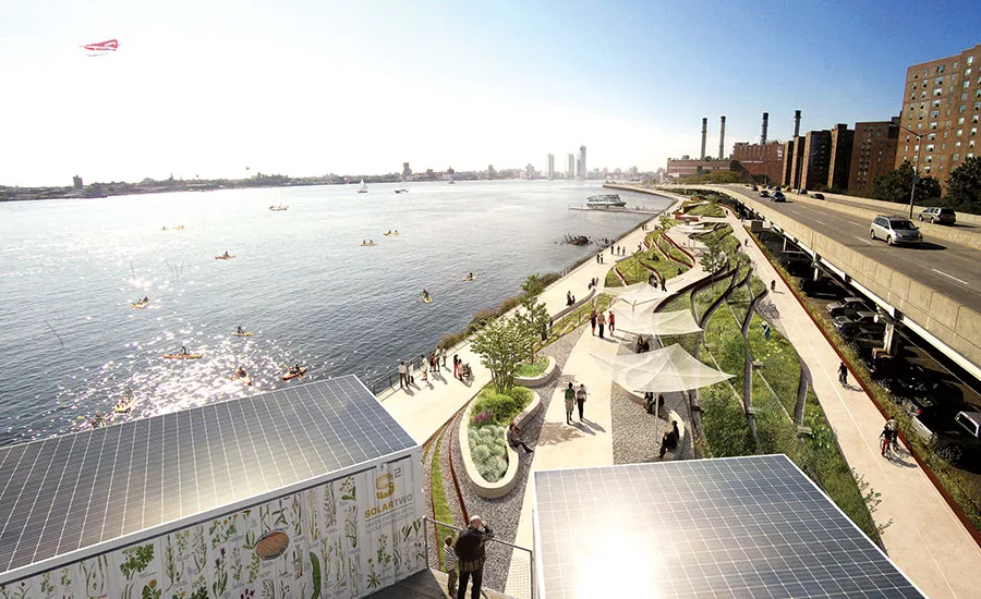
A redesigned Stuyvesant Cove Park will serve as a storm buffer, with landscape features that can survive inundation.
Rendering courtesy Bjarke Ingels Group
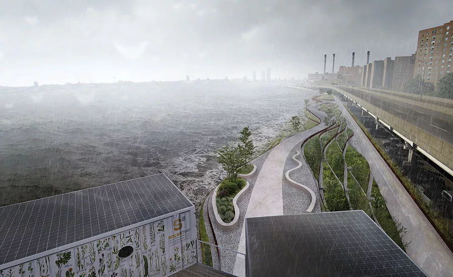
A redesigned Stuyvesant Cove Park will serve as a storm buffer, with landscape features that can survive inundation.
Rendering courtesy Bjarke Ingels Group
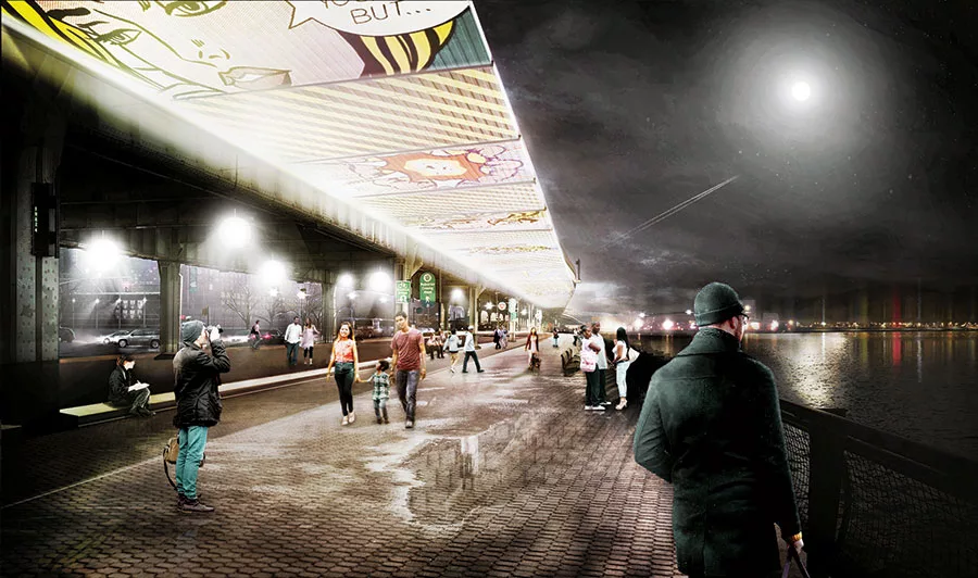
The Big U will have some active flood-control elements, such as a flip-up gate that can be used in a variety of modes and in different weather conditions.
Rendering courtesy Bjarke Ingels Group

The Big U will have some active flood-control elements, such as a flip-up gate that can be used in a variety of modes and in different weather conditions.
Rendering courtesy Bjarke Ingels Group

The Big U will have some active flood-control elements, such as a flip-up gate that can be used in a variety of modes and in different weather conditions.
Rendering courtesy Bjarke Ingels Group
Plans for Bridgeport, Connecticut, include a new park with a water-retention pond. It will help slow stormwater runnoff, easing the burden on the city’s sewer system.
Rendering courtesy Waggonner & Ball
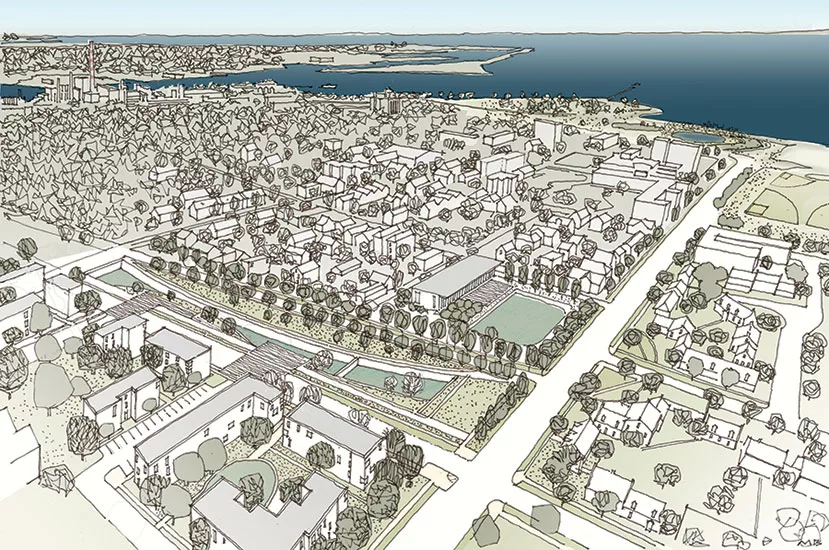
The Bridgeport scheme calls for raising some streets in the city’s South End.
Image courtesy Yale Urban Design Workshop
The raised streets would work in conjunction with naturally occuring glacial ridges to create a network of resilient corridors.
Image courtesy Andrew Sternad, Yale Urban Ecology & Design Lab
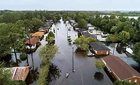
In the aftermath of the damage wrought by hurricanes Harvey and Irma, many residents in areas surrounding Houston, in the state of Florida, and throughout the Caribbean are struggling to satisfy their immediate and most basic needs. But as the devastated communities start thinking about long-term recovery efforts, they will need to carefully consider their rebuilding strategies. Rising sea levels and warming ocean temperatures will only increase the intensity of future storms and the threat to coastal cities and towns.
Places to look for examplars are New York and Connecticut, where projects aimed at improving resilience are nearing construction, five years after Hurricane Sandy slammed into the region. Two infrastructure projects in particular, one for Lower Manhattan and another for Bridgeport, Connecticut, could provide lessons in preparing for the next superstorm.
The two schemes were among the winners of the 2013 Hurricane Sandy Design Competition, whose goal was to address social and structural vulnerabilities in the cities and towns affected by the storm. Known as Rebuild by Design (RBD), for the nonprofit created to oversee it, the competition resulted in more than $1 billion in awards from the Department of Housing and Urban Development (HUD), providing seed money, as well as funds for implementation, of a number of projects in the New York metropolitan region and beyond.
Architecture firms play a leading role in the RBD teams, which are also made up of landscape architects, scientists, and engineers from the U.S. and abroad. This multidisciplinary framework was an essential aspect of the multistage competition, says Amy Chester, managing director of RBD. Each team was encouraged to include international participants and engage in extensive collaboration with residents and local governments and other stakeholders, she explains.
A team led by the Danish firm Bjarke Ingels Group (BIG) produced the scheme known as “The Big U,” a buffer that relies on an assortment of strategies and both “hard” traditional infrastructure, such as walls and gates, and “soft” elements like green space and berms, which would double as community social and recreational areas. It will wind around the shoreline in the shape of a “U” and protect the southern tip of Manhattan from storm surges and flooding.
Design-team members are fond of referring to this combination of large-scale, highly engineered elements and more human-scaled strategies as the outcome of an imaginary partnership between Robert Moses, the planner behind much of New York’s megascale mid- 20th century urban renewal, and Jane Jacobs, the influential activist who championed the richness and diversity of neighborhoods. “We think of the Big U as the love child of the two famous adversaries,” quips Jeremy Alain Siegel, project leader in BIG’s New York office.
Since the competition, the BIG U has been divided into two implementation phases: the East Side Coastal Resiliency (ESCR) project, which stretches for 2.2 miles along the East River, from 25th Street to just south of the Williamsburg Bridge, and the Lower Manhattan Coastal Resiliency (LMCR) project, which extends below the Manhattan and Brooklyn Bridges to the Battery. The two are further segmented into several discrete flood protection zones, or “compartments,” defined by “tie backs” made up of barriers and operable floodgates. But as a whole, the Big U favors passive protections, including berms and walls, over deployable devices. The approach should reduce maintenance requirements and the likelihood of system failure due to power outages or human error, explains Siegel.
Looking for quick answers on architecture and design topics?
Try Ask RECORD, our new smart AI search tool.
Ask RECORD →
With construction slated to start in 2019 and be completed by 2025, the design for the ESCR, for which almost $800 million in federal and city funds have been committed, is the most developed of the two phases. It will improve pedestrian connections across the multilane FDR Drive to the East River and Stuyvesant Cove Parks with broad and sinuous footbridges. The pair of narrow parks, which are wedged between the roadway and the water, will be rebuilt to include diverse social spaces and topographical variety, gradually stepping up in elevation as they move away from the water’s edge. According to Siegel, many of the parks’ features will emulate natural systems such as wetlands, barrier islands, and dunes, and protect the coastline by buffering waves and storm surges.
To mitigate flash flooding, the ESCR will also have plenty of porous and pervious surfaces as well as temporary stormwater storage. The team is also currently exploring options for retention basins, including recessing paved recreational areas, such as basketball courts. These could be designed to fill with water during heavy downpours and, once flooding subsides, they would be slowly drained, easing the burden on the city’s sewer system.
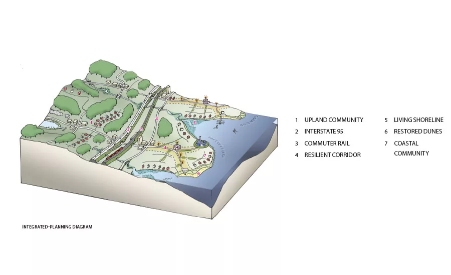
Sixty miles up the coast from Manhattan, a similar combination of hard and soft infrastructure strategies is planned for Bridgeport, Connecticut, which straddles the Pequannock River and lies exposed to the Long Island Sound on a set of peninsulas. The once-thriving industrial city was hard hit by Hurricane Irene in 2011, and then Sandy a year later.
“The tendency is to look only at the infrastructure, but the first thing to consider are the natural systems,” says David Waggonner, president of New Orleans–based Waggonner & Ball, which is leading the Rebuild by Design team known as Resilient Bridgeport. Tapping into Dutch flood-control expertise, the firm has developed an urban water plan for its home city, as well as other towns and regions.
The Bridgeport team’s plan makes the most the city’s existing assets, including Seaside Park, designed by Fredrick Law Olmsted. Although the city sustained substantial flood damage from Sandy, this swath of green space along the coast helped buffer low-lying areas from the full intensity of the storm surge. The Resilient Bridgeport scheme takes advantage of this parkland, while weaving in new protective barriers in strategic places.
The new barriers, which will be combined with natural mitigation components, are in some instances berms and in others seawalls, and will sometimes be located near the water’s edge and at others pulled several blocks inland, leaving an area to cushion the storm surge.
These protections are one of four HUD-funded Resilient Bridgeport projects, all concentrated near the city’s South End, slated to begin construction in 2019. With a total budget of about $47 million, this first phase will also include raising some neighborhood streets, creation of a South End Stormwater Park, and construction of a Resilient Bridgeport Center that will serve as a community educational facility.
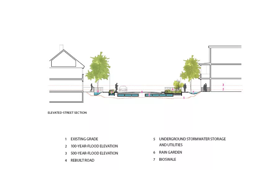
By raising some roadways, the project will provide a means of dry egress from low-lying areas. The elevated streets, which would be roughly at the first-floor level of the adjacent houses, will connect to their front stoops via small bridges. The space in between the houses and the new roadway could house rain gardens for slowing and absorbing runoff, while the space below the street surface could be used for box culverts and utilities. The new streets will connect to naturally occurring glacial ridges that run perpendicular to the water, forming a waffle-like network of resilient corridors. A similar plan is being implemented in other coastal cities such as Miami Beach, where key roadways are being raised to serve as protection and as routes where vehicular traffic can travel unimpeded during floods.
For dealing with heavy rainfall, which can overwhelm the city’s antiquated combined sewer system, Resilient Bridgeport relies on a “delay and convey” strategy similar to that proposed for Lower Manhattan. The approach emphasizes green infrastructure such as bioswales, green roofs, and temporary water storage to slow runoff. These tactics will be used in combination with gray infrastructure (pumps and pipes) and some raised streets in the 2½-acre Stormwater Park planned for a site into account. “That agency allows you to count ecological and quality-of-life benefits. It’s a softer accounting method,” Waggoner explains. Both projects have favorable benefit-to-cost ratios, with the ESCR at 2.8:1 and the Bridgeport Stormwater Park at 1.6:1. Anything above 1:1 is considered cost-effective.
The analyses show that the benefits of projects like those planned for Lower Manhattan and Bridgeport far outweigh the risk of doing nothing. Though not yet built, they present a powerful argument against the Trump administration’s efforts to defund climate-change-related programs and roll back policies intended to protect flood-prone areas. Waggonner remains committed to improving the resilience of coastal cities. “It’s all about persistence,” he says, citing his own city: “A lesson from New Orleans is that the challenges keep changing, but you have to persevere, check your direction, see where you are, and move ahead.”
|
Continuing Education
 To earn one AIA learning unit (LU), including one hour of health, safety, and welfare (HSW) credit, read the "Continuing Education: Designing for Coastal Resilience," review the supplemental material listed below, and complete the online test. Upon passing the test, you will receive a certificate of completion, and your credit will be automatically reported to the AIA. Additional information regarding credit-reporting and continuing-education requirements can be found online at continuingeducation.bnpmedia.com. To earn one AIA learning unit (LU), including one hour of health, safety, and welfare (HSW) credit, read the "Continuing Education: Designing for Coastal Resilience," review the supplemental material listed below, and complete the online test. Upon passing the test, you will receive a certificate of completion, and your credit will be automatically reported to the AIA. Additional information regarding credit-reporting and continuing-education requirements can be found online at continuingeducation.bnpmedia.com.Supplemental Material
Rebuilding with Resilience: Lessons from the Rebuild by Design Competition after Hurricane Sandy Georgetown Climate Center Pages 1 through 5
Learning Objectives 1 List some of the strategies that are often referred to as “green” or “soft” infrastructure. 2 Discuss how green infrastructure and traditional hard infrastructure can be combined to protect coastal cities from flooding, sea-level rise, and storm surge. 3 Outline the resilience-strengthening measures planned for Lower Manhattan and Bridgeport, Connecticut. 4 Discuss how cost-benefit analyses are calculated for infrastructure projects.
AIA/CES Course #K1710A
For CEU credit, read Wellness in the Workplace and take the quiz at continuingeducation.bnpmedia.com, or use our Architectural Record Continuing Education app, available in the iTunes store. structure, finishes, and other original fabric when
a building is moved.
significant buildings.
|
Looking for a reprint of this article?
From high-res PDFs to custom plaques, order your copy today!