Continuing Education: Coastal Resilience
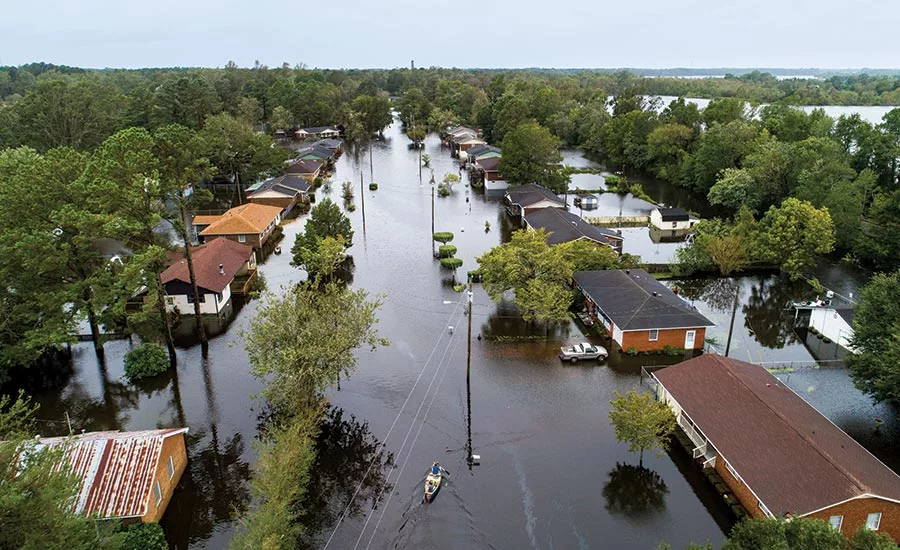
During last September’s Hurricane Florence, the small North Carolina city of New Bern was inundated by the compound effects of storm surge and river flooding.
Photo © Jim Lo Scalzo / Shutterstock
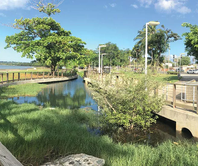
In Mayagüez, Puerto Rico, Local Office Landscape and Urban Design and architect Javier Bonnin Orozco created a beachfront park that includes wetlands capable of storing storm-surge waters.
Photo © Local Office Landscape and Urban Design
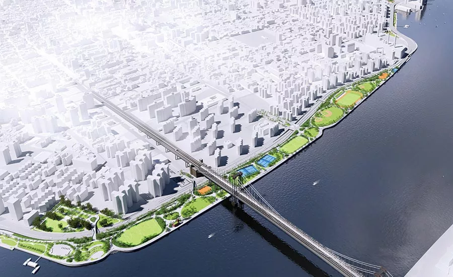
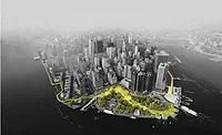
A team that includes AKRF and BIG has developed a flood-protection scheme for 2.4 miles along New York’s Lower East Side (shown). It calls for raising the elevation of an existing park about 8 feet.
Rendering courtesy NYC Mayor's Office of Resiliency
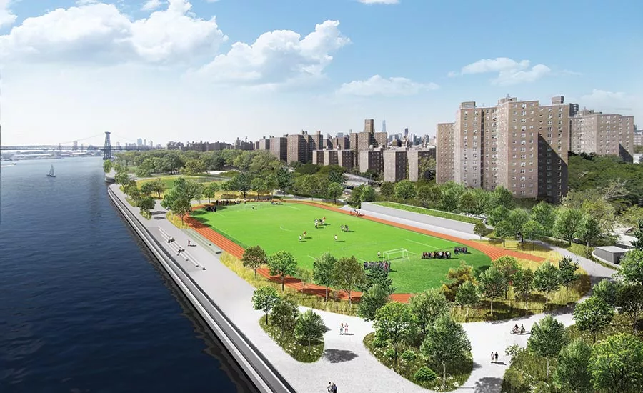
A team that includes AKRF and BIG has developed a flood-protection scheme for 2.4 miles along New York’s Lower East Side. It calls for raising the elevation of an existing park about 8 feet (shown).
Rendering courtesy NYC Mayor's Office of Resiliency
On New York’s Staten Island, once-degraded stream beds have been restored and linked together. The network helps control outflow volume and prevent flooding in low-lying neighborhoods.
Photo © James S. Russell, FAIA
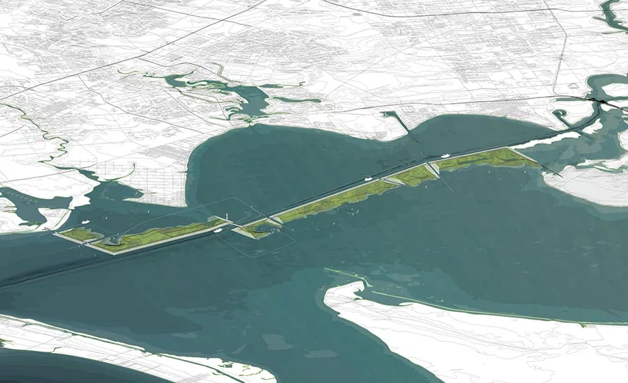
Rogers Partners Architects and collaborators propose combining hard and soft flood protections for Galveston Bay that would include floodgates and new parkland, created from soils dredged from a shipping channel.
Image courtesy Rogers Partners
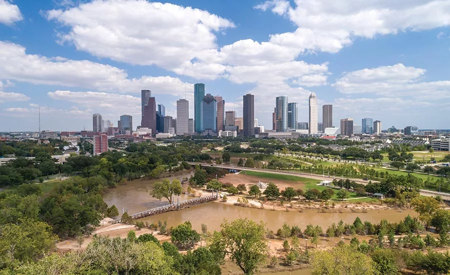
SWA Group’s Buffalo Bayou Park in Houston, completed in 2015, included reconfiguring the watercourse to control runoff. Though inundated during Hurricane Harvey in 2017 (shown), the landscape proved resilient and was quickly restored.
Photo © Jonnu Singleton / SWA Group
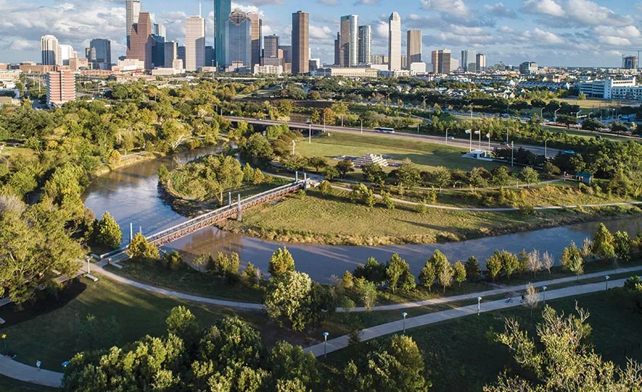
SWA Group’s Buffalo Bayou Park in Houston, completed in 2015, included reconfiguring the watercourse to control runoff. Though inundated during Hurricane Harvey in 2017, the landscape proved resilient and was quickly restored (shown one year after the hurricane).
Photo © David Lloyd / SWA Group
In November 2018, New Bern, North Carolina, could not have looked more peaceful. Along a waterfront park, calm waters lapped the shoreline barely 3 feet below sidewalk level. The compact redbrick 18th-century town looked to be an island, surrounded by long stretches of unruffled water to the east and south. The city of 30,000 people is actually located at the confluence of two rivers, the Neuse and the much smaller Trent, but the combined streams broaden as they flow into Pamlico Sound just seven miles away on the Atlantic coast.
On closer look, however, the destruction wrought by Hurricane Florence, two months earlier, was still evident. Porches on riverfront houses had been wrenched askew by floodwaters. Brick foundation walls had been swept away. A massive tree had crushed a small cottage.
Florence inundated New Bern beginning on September 13. First it was the storm surge, driven by the hurricane from the coast inland, where it collided with the rain-swollen rivers. As time passed, the rivers continued to rise, carrying the runoff from heavy rain that had been falling for days as far away as Raleigh-Durham, 100 miles northeast. New Bern was cut off for weeks and suffered $100 million worth of damage. The City Manager’s Office counted up 235 businesses and 1,761 houses that were affected.
With hurricanes a regular event along the coast of the Carolinas, catastrophic flooding is a known risk. But the intensity and level of damage from Florence was unprecedented, signaling one more way that the climate crisis is exacerbating and complicating the problem of protecting communities from storm-driven floods, as well as from more frequent tidal flooding caused by rising seas.
While people typically associate the high winds that down trees and power lines as the most destructive part of severe storms, “wind speed doesn’t tell you enough about the kind of damage hurricanes will cause,” explains Robert S. Young, the director of the Program for the Study of Developed Shorelines at Western Carolina University in Cullowhee. “More common today are big fat storms pushing a lot of water in front of them.”
Increased rainfall and more intense and longer-lasting storms are trends that are likely to intensify as the planet continues to heat up, according to the Intergovernmental Panel on Climate Change. Such torrents overwhelm conventional storm-drainage systems, hurling overflows toward shorelines, bays, or river outfalls just as storm surges crash over bulkheads. The flooding in the lowest-lying areas is much more severe than historical norms—as Hurricane Harvey demonstrated in 2017 when it came to a stop over greater Houston, shattering records with as much as 50 inches of rain. And don’t be confused by how severe storms are measured: a 100-year event does not mean such storms will only happen once a century but that they have a 1 percent chance of occurring in any given year. That’s why communities can experience two or more “100-year” storms in the space of a few years. Yet stormwater systems are usually designed to manage only a 5- or 10-year storm, and, with more frequent severe storms, local drainage systems are falling behind.
Until recently, standard practice for coastal communities in the U.S. was to build protective shoreline barriers such as bulkheads (usually concrete, timber, or sheet piles) and revetments (sloped walls made of large, stacked rocks) intended to be permanent. This approach is often referred to as a “hard path” method because the barrier is fixed, but it loses value once overtopped, which, frighteningly, is happening much more often. And while bulkheads can be useful where there is little space along the shoreline, this type of engineered armor is now often considered a last resort, since it can exacerbate erosion and harm the rich ecological continuum between the waterfront and upland environments, leaving shorelines largely devoid of habitat. In recreational areas too, hard-path protections considerably diminish the visitor experience.
Looking for quick answers on architecture and design topics?
Try Ask RECORD, our new smart AI search tool.
Ask RECORD →
Instead, natural-system solutions that can adapt to changing conditions provide multiple benefits. These “soft path” tactics include dune systems, planted waterway edges that may be partially reinforced with structured terraces, constructed marshlands, and ponds. Naturalized stream basins include elements, such as wider stream beds and oxbows, that slow the flow of water and hold it until conventional piped drainage systems catch up. These strategies, at neighborhood or even watershed scale, include “green infrastructure” practices that are already used across the country to augment older storm-drainage systems. Also referred to as low-impact development, these practices encompass green roofs, permeable surfaces, subsurface tank installations, linear bioswales, and bioretention basins to retain water (infiltrating it into the soil to keep it out of the storm-drainage system) or detain water (storing it or slowing its flow until peak flooding passes). Designing soft-path protections demands a team of specialists in hydrology and wetland ecology, but architects and landscape architects play a role in integrating these installations into sites and neighborhoods.
Such soft systems have succeeded in places like Puerto Rico, which was devastated by Hurricane Maria in 2017. The storm tested the 1.2-mile-long Parque del Litoral, a beach park in Mayagüez. It is a pioneering project combining shoreline protection and upland water management by New York–based Local Office Landscape and Urban Design working with local architect Javier Bonnin Orozco. It cut off old stormwater pipes that had previously dumped polluted runoff into the bay. Instead, day-to-day runoff is biologically treated in wetlands constructed inland of a dune and low enough to store a considerable amount of storm-surge water. Trees and shrubs were planted to help diffuse the energy of a storm surge, and the accompanying high winds. Parking and recreation spaces were installed with porous pavement to infiltrate runoff, reducing the drainage burden. The commercial street on the inland edge of the park was raised to direct surface runoff toward the wetlands. After Maria, local businesses reported that the park, which opened in 2010, protected their buildings. Streets turned into streams, but they flowed away from buildings and into the wetlands as designed. The park itself sustained little more than cosmetic damage.
Yet navigating the politics of complex jurisdictions can make implementing optimum soft or hybrid systems problematic—as New York is discovering with its ambitious plan to protect 2.4 miles of low-lying waterfront along Manhattan’s Lower East Side. The project came out of “the Big U,” a scheme devised by a team led by the Bjarke Ingels Group (BIG) and one of the winners of the 2013 HUD Rebuild by Design competition. (The competition was conceived to generate innovative flood-resilience solutions for communities affected by Hurricane Sandy that could be widely applied.) Envisioned as a series of berms, walls, gates, and other devices, the Big U would form a continuous barrier, wrapping Lower Manhattan.
Now led by engineering firm AKRF, and including BIG, the City’s Department of Design and Construction (DDC) has proceeded with a first phase, called East Side Coastal Resilience, that would protect the most vulnerable stretch along the East River. Two years in, the project was delayed and expensively revised to add a network of storage pipes that will run inside the barrier, because the amount of inland runoff had been underestimated. (Disclosure: I worked for DDC, but not on either of its projects discussed in this story.)
In fall 2018, the team unveiled another major revision. Designed in secret, this latest scheme would replace an existing 57.5-acre park along the river, raising it about 8 feet, an elevation higher than anticipated 100-year floods. The original design would have placed the protective elements inland of the park, adjacent to a major highway, leaving the park largely unaffected. The new design, by raising the bulkhead at the water’s edge to the necessary height, requires the replacement of the park at the higher level on fill. Even with the much-expanded scope this change entails, the City “will deliver protection one full hurricane season sooner than the original design,” according to Phil Ortiz, spokesman for the Mayor’s Office of Resiliency, which is overseeing the project.
Meeting a 2023 expiration date for HUD funding and other issues of operational and construction convenience appear to have been the motivation for the change in approach—resulting in a project of diminished quality in the eyes of neighbors shut out of the redesign process. “We are deeply disappointed with the City’s last-minute rationale to spend an additional $700 million [for a total cost of $1.45 billion] without studying alternatives or fostering a public conversation on tradeoffs,” said a statement by the organizations that had led the Rebuild by Design competition.
The City could have learned lessons from a decades-long project in its own backyard that is a national model for reducing the effects of inland storms and flooding. DDC has linked and upgraded stream fragments on Staten Island to create a network of stormwater-management waterways called Bluebelts. The program restores degraded stream beds with widened channels and naturalized edges. The streams and piped drainage flow into constructed stormwater ponds and wetlands that filter trash and control outflow volumes. With water managed at stages along the length of each stream, torrents no longer inundate the lowest-lying communities near the shore. Such incremental and low-tech solutions grow in appeal as the Federal government finances fewer projects that rely principally on large-scale civil-engineering works, such as East Side Coastal Resilience.
Indeed, when Hurricane Harvey flooded the vast oil, gas, and petrochemical-processing infrastructure that lines the shipping canal at the head of Galveston Bay east of Houston in 2017, a $30 billion protection project, long in planning by the U.S. Army Corps of Engineers but short on Congressional commitment, began to look far too expensive, despite the storm’s devastating effects.
Now New York–based Rogers Partners Architects, collaborating with Rice University’s Severe Storm Prediction, Education and Evacuation from Disasters Center and Walter P. Moore, a local infrastructure-engineering firm, have devised Galveston Bay Park, a conceptual plan that claims to be a more economical solution. Some 12 miles of 25-foot-tall rock revetments are proposed to line an existing channel dredged through the shallow bay. Nine gates would close to seal the shipping- canal entrance and protect industrial areas on the east side of the bay during severe weather.
Soils dredged in doubling of the width of the channel would be placed behind the revetments to build up parkland and natural-habitat edges, creating some 10,000 acres of new destination parkland for the metro area. The plan is “building allies” among business, civic, and environmental groups, says principal Rob Rogers. Besides all the auxiliary benefits, the project is estimated to cost far less than the earlier plan, at $2.3 billion. “The era of single-purpose infrastructure is over,” says Rogers. “Everything we build now needs to be multifunctional.”
Galveston Bay Park would expand on a soft infrastructure that already helps manage flooding in Houston. Upstream of downtown and the shipping canal is the slow-moving Buffalo Bayou, a 2.3-mile stretch of which was upgraded in 2015 with a widely trails as well as performance venues, and an obsolete waterworks converted for art display. The design for the Buffalo Bayou Partnership, by the SWA Group, included enhancing the degraded ecology of the waterway and configuring the watercourse to control storm runoff that raises the bayou level by as much as 20 feet, several times a year. Natural meanders were restored to slow eroding flows, and the channel topography was shaped to capture silt. Architectural elements resist flood pressures and collisions from floating debris.
The design was subjected to Hurricane Harvey’s record-breaking torrents and survived with little damage. Impressed, voters soon approved funding to move ahead with a Bayou Greenway plan to create trail corridors, new parks, and flood-mitigation facilities along 300 miles of bayou stream beds. Though the Buffalo Bayou project enhanced an existing stream, most cities possess underutilized low-lying land that can host natural-system improvements and increase drainage capacity, slow flows, clean stormwater, and offer amenity.
While soft-path techniques can be more adaptable than fixed barriers, some places find neither approach is likely to defend their communities from the almost inevitable ravages of rapid climate change. In New Bern, this is becoming a hard reality. Since the city occupies a vast coastal plain that is barely higher than sea level now, not enough levees and walls can be built to be effective. Nor will low-impact development provide appropriate protections. “Green infrastructure is probably not relevant” for the coastal plain, says Western Carolina University’s Young.
New Bern residents—at least those who can afford to or who qualify for government grants—are adapting to the presence of water by raising their homes. Buyouts are offered property by property in North Carolina, which could mean a slow but steady loss of population for New Bern and other high-risk cities. With more shorelines suffering greater damage, and less money for civil-engineering megaprojects, the next frontier in disaster risk may be the managing of such retreat at a larger scale. After all, within decades, the lowest-lying shoreline and barrier islands could well be permanently inundated by rising seas.
|
Continuing Education
 To earn one AIA learning unit (LU), including one hour of health, safety, and welfare (HSW) credit, read "Continuing Education: Coastal Resilience," review the supplemental material listed below, and complete the online test. Upon passing the test, you will receive a certificate of completion, and your credit will be automatically reported to the AIA. Additional information regarding credit-reporting and continuing-education requirements can be found online at continuingeducation.bnpmedia.com. To earn one AIA learning unit (LU), including one hour of health, safety, and welfare (HSW) credit, read "Continuing Education: Coastal Resilience," review the supplemental material listed below, and complete the online test. Upon passing the test, you will receive a certificate of completion, and your credit will be automatically reported to the AIA. Additional information regarding credit-reporting and continuing-education requirements can be found online at continuingeducation.bnpmedia.com.Supplemental Material
NYC’s Risk Landscape: A Guide to Hazard Mitigation, May 2019 NYC Emergency Management Chapter 5, Flooding; Pages 82 to 95
Learning Objectives 1. Explain the interaction of storm-related coastline flooding and stormwater overflows originating inland. 2. Describe the changing nature of severe weather as climate-change effects intensify. 3. Define the terms “hard path” and “soft path” and explain when each type of flood protection is appropriate. 4. Describe the application of natural-system techniques to adapt shorelines and inland streams to changing conditions and reduce flood impacts.
AIA/CES Course #K1908A
For CEU credit, read "Continuing Education: Coastal Resilience" and take the quiz at continuingeducation.bnpmedia.com, or use our Architectural Record Continuing Education app, available in the iTunes store. structure, finishes, and other original fabric when
a building is moved.
significant buildings.
|
Looking for a reprint of this article?
From high-res PDFs to custom plaques, order your copy today!