Before the Architecture
An urban planning expert identifies the real next steps for the World Trade Center site.


With the intense scrutiny that has been focused on the site of the World Trade Center in the last 13 months, it would be foolhardy to suggest that any one person knows that site better than any other. Certainly the managers of the deconstruction job that recently finished are intimately aware of the site’s intricacies, even more so than many of the architects who have presented plans for the area’s renewal. But many of those plans suddenly seem disconcertingly naïve when subjected to the scrutiny suggested by Craig Whitaker, an architect, urban planner and an adjunct professor of urban planning at New York University. In fact, “architecture” may be several steps away.
Whitaker, with the help of students and the staff at Craig Whitaker Architects, undertook a months-long study of the planning issues that face potential World Trade Center designers before anything else can be done. The following pages present a brief precis of Whitaker’s study, which is entitled ‘Next Steps, Hard Choices,’ as well as an in-depth interview with Whitaker about those next steps in the design process.
Craig Whitaker: Did you see Herbert Muschamp’s piece in the magazine section of the New York Times? [Muschamp, the New York Times architecture critic, curated a proposal for lower Manhattan. The collaboration among almost two dozen architects imagined a string of buildings above an underground West Street.]
Kevin Lerner: What are your thoughts on that?
Whitaker: I actually thought it was irresponsible, because you can’t build those buildings that way. You need to ventilate the highway. And rather than dealing with the problem at Ground Zero, they simply picked an alternative site in order to showcase the architects that Muschamp picked. It can’t be built because you can’t ventilate the highway, and the second fact is that the Federal Highway Administration is not going to pay for almost a mile of footings and foundations and columns for buildings that might not be built for thirty years, for developers that don’t exist, for programs that haven’t been crafted.
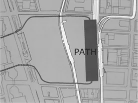
Lerner: You had mentioned a similar problem in building the new PATH station.
Whitaker: In this particular instance, there’s strong precedent. The Ford Foundation had commissioned Paul Rudolph to do something in a publication called the future of the city. This was at a time when the Lower Manhattan Expressway [a plan to build an east-west highway across the island, circa 1955–1963] was a burning issue. Rudolph proposed building housing over the highway, and of course it went nowhere because the Federal Highway Administration wasn’t going to pay for a very expensive set of footings that was going to stretch the entire width of lower Manhattan.
Looking for quick answers on architecture and design topics?
Try Ask RECORD, our new smart AI search tool.
Ask RECORD →
Lerner: How would a project like this compare with the Big Dig in Boston? [An ongoing plan in Boston is burying the Central Artery and replacing it with developable land and parks.
Whitaker: I have no idea about the buildings. The highway, the number that’s being used informally is $2 billion, and that would be for something that stretches from Chambers Street down to the Battery. The Big Dig is something in the neighborhood of $15 billion.
Lerner: But that includes, in some places, supports for buildings, does it not?
Whitaker: Yeah. Exactly. What they had to do there—and this is something that would have to be thought through here—is build a temporary roadway. That’s essentially what makes projects like this so expensive, and why, by comparison, Westway was so inexpensive. [Westway, a project that was under debate in the late 1970s and early 1980s, would have replaced the West Side Highway, and in some proposals, included a depressed and partially covered section in the existing West Street right-of-way in lower Manhattan.] What you have to do is go in and build a temporary roadway, relocate traffic to that roadway. Then go in and do what you have to do, and then tear down the temporary roadway. So in many urban areas, you’re actually building two roads, both of which have to be structured to carry what, in highway terminology is called HS-20 loading, you know, it’s a moving van, or a fully-loaded pumper truck or something like that.
Lerner: Does the public know this? Is education the first step?
Whitaker: Yeah. I think if the LMDC [Lower Manhattan Development Corporation] continues the battle of images—and Muschamp’s piece was simply the latest in a flood of suggestions and ideas—then it loses, because it has to grapple with the real-world problems of money, of scheduling, of transit questions and right-of-ways that will be needed underneath the ground, with the existing leaseholders, and with the public participation process.
In the alternative, it would be better for the LMDC to break down the pieces of the redevelopment project, and begin to show the public what the consequences are of each of these decisions. For instance, there has been a considerable amount of talk about the 11 million square feet of office space and how it’s hampering efforts because it’s taking up space that could otherwise be used for housing or the memorial or parks or streets or whatever. If you do the math, it’s a very simple exercise. Just take 51 stories and divide it into 11 million square feet, and you get less than 5 acres out of what’s an 18 acre site—18 meaning 16 acres, plus two acres that you would get if you narrow the streets. If it were 65 stories, you could do it in less than four acres. Just take 11 million and divide it by 65, and divide that number by 43,560 square feet per acre. And I don’t think the public completely understands that.
We’ve given a lot of lip service to the lower Manhattan skyline, but I don’t think that the public understands that a lot of buildings down there were built on very ordinary looking footprints, which is not necessarily an inhibitor to good architecture. The Woolworth Building, 40 Wall Street, City Services…. If you were to try to find them on a map, you wouldn’t be able to identify them. In fact, if you look at most great New York Buildings, they sit on very ordinary looking footprints. The Empire State Building, the Chrysler Building, the Whitney, the Guggenheim. So I think there needs to be an effort there to make the public understand that. A relatively simple stitching-together of the streets doesn’t mean that we’re headed down the road to mediocrity. I think the public doesn’t understand that we’re not imminently going to be building the 11 million square feet because we have office rents down there that are 25 bucks a square foot less than what it would take to build a fully tax-paying office building.
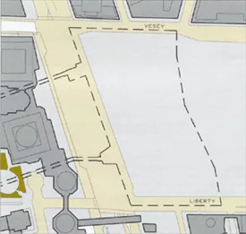
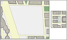
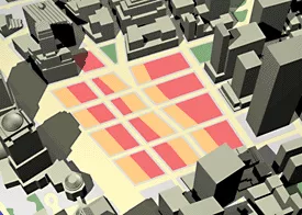
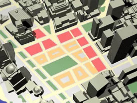
I also don’t think that the public really understands the size of the acreage down there. A good part of the debate about the memorial has also centered on how big it should be, rather than what its context should be. At Rockefeller Center, the skating rink is less than three quarters of an acre. And even if you add the allée going in from Fifth Avenue, it’s a little more than three quarters of an acre. If you were to look at Gramercy Park, which is one of my favorites, it’s a little more than an acre and a half. So how you surround the memorial is far more important than the size of it. And nobody’s looked, at how in the two footprint alternative, that unless there’s a drastic change, the southern border of the memorial would be a small parking lot, the Deutsche Bank, which is one of the ugliest buildings in lower Manhattan, and on the next block to the east, Burger King. Is that an appropriate way to frame the memorial? I don’t think so.
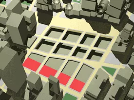
The question of where the PATH [Port Authority Trans-Hudson] train goes has enormous implications for transit patterns in lower Manhattan. I believe, but I don’t have the evidence, that it’s better to move the station to Church Street. But this is the kind of question that can be put in very quantifiable terms. A lot of transportation planning depends on numbers: minutes saved can be equated with dollars saved, versus the cost of providing the solution that saves the dollars. In other words, it may be, in the end, cheaper, in terms of access into lower Manhattan, to move the station. There are very good arguments that can be made for keeping the station where it is. It’s much cheaper. And at the same time, you can encourage retail by surrounding the station in the middle of the World Trade Center site with stores. Everyone who passes in and out of the station becomes a shopper or a browser past the store, where you might but something. None of this has really been brought before the public in any kind of a systematic way.
Lerner: What sort of system do you suggest?
Whitaker: I think you take each of these pieces and you prepare a critical path, much the way you would in a complicated construction process: What do we have to decide today? Well, very soon, you have to make the decision on the PATH station. It will influence the columns; it’ll influence the location of commercial space above it. The public needs to have a full-scale presentation on what these alternatives are, if in fact the public’s going to be involved, and then the decision makers are going to have to make a decision. Under the National Environmental Policy Act, on highway projects, for instance, you’re required to do this anyway. You’re required to come before the public with alternatives and explore the environmental and aesthetic and economic consequences of each of these decisions before you make a choice.
Lerner: Who is the public? Who needs to be involved in this?
Whitaker: I think it’s somewhat sui generis, it’s whoever decides to be involved. But clearly with something of this symbolic import, thousands of people have said they want to be involved, and it becomes a messy process. Do we take a vote? No, of course we don’t. We have hired politicians to make these decisions. But they make the decisions after listening to the public debate. But we’re not having a public debate on any of these issues. The question of producing residential real estate in lower Manhattan is a laudable goal, but I don’t know where the soft sites are; I don’t know how much one would be willing to pay.
For instance, the Deutsche Bank. I have a fellow that I work with regularly, and think very highly of, who put out a number of 400 bucks a square foot to buy and develop real estate in lower Manhattan. The Deutsche Bank at 1.2 million square feet, you’re looking at a purchase price of $480 million, less what it costs to get the mold out of the building. It’s almost a half a billion dollars. Is that an appropriate public expense? Well, I’m from Missouri; you’d have to show me. I think we could have one whole component on residential. I think we could have one whole component on shaping the skyline. In Switzerland, you’re required to build a mock outline of a building out of bamboo. There’s no reason we couldn’t be studying each of the buildings that’s being proposed in lower Manhattan by using computers and film or photographs so that people can see them.
I don’t think the public understands the relationship between the size of a building footprint and elevator service and height. It’s often more profitable for a developer to build—I’m making these numbers up—say 72 stories than 75 stories. I don’t think that the public understands that this is how buildings get built over time. I don’t think the public understands how a typical office building is structured as a financial deal: you have to have an anchor tenant. You need to go to the bank and borrow on the rest.
Looking for a reprint of this article?
From high-res PDFs to custom plaques, order your copy today!


