Public Space Portfolio
Revitalization of the Civic Realm
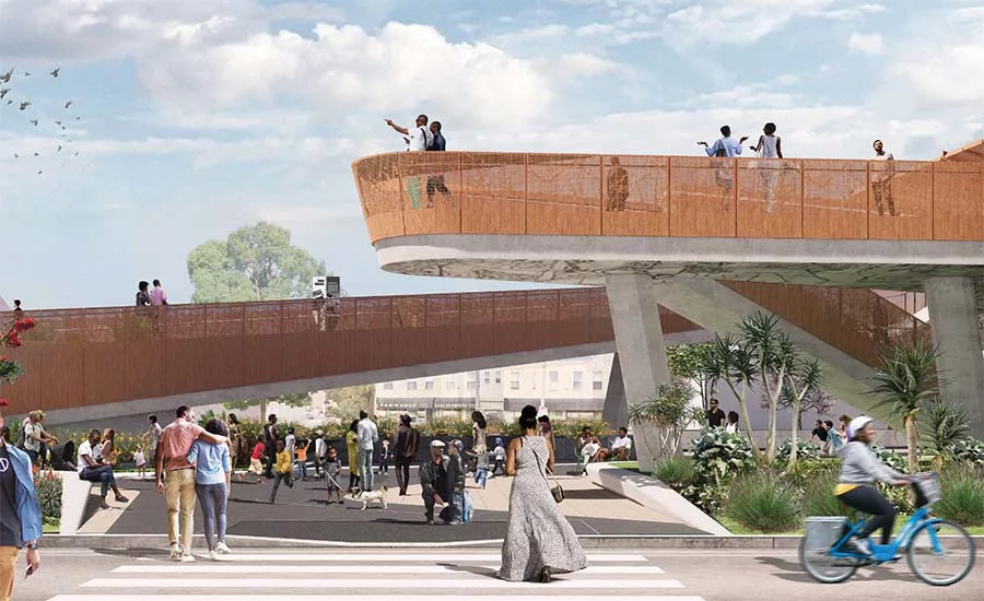
L.A. light-rail. Image courtesy Perkins + Will
Various proposals nationwide show how parks and common areas can be created from a torn urban fabric.
L.A.: Light-rail leads to lookouts and art display
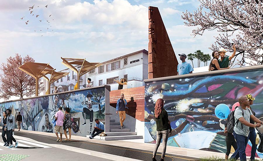
Image courtesy Perkins + Will, click to enlarge.
Los Angeles’s Crenshaw Boulevard is often considered the premier artery of African-American commerce and culture in the western United States. “Crenshaw is to L.A. what 125th Street is to Harlem,” as one local leader put it. Yet when plans were unveiled, in 2011, for a new light-rail line down the center of that boulevard, the Black community rightfully felt blindsided. Without any warning, the county had decided to drive 1.3 miles of track through the heart of Black L.A., right at grade—even though much of the remaining Crenshaw/LAX Line will run underground. Worse yet, the plan included no stations or stops along that stretch. “It felt like an updated version of the ways freeways and tracks had torn through underprivileged neighborhoods in the ’40s, ’50s, and ’60s,” said Jason Foster, who’d worked elsewhere in L.A. to reclaim such infrastructure-damaged communities. “Suddenly, it was happening all over again.”
But this time, the community mounted a strong response, determined to turn adversity to advantage. Local councilman Marqueece Harris-Dawson spearheaded the formation of a visionary advisory council, made up of area artists, activists, business owners, ordinary citizens, and other stakeholders. With active community input, “Destination Crenshaw” was born. Foster became its president and COO. The $100 million project, due in June 2022, will create, along its 1.3 miles, 10 much-needed pocket parks, walkable sidewalks, two train stops, and installations, both permanent and rotating, by more than 100 emerging and world-renowned artists of African descent, most with roots in L.A., including Charles Dickson, Melvin Edwards, Maren Hassinger, Artis Lane, Alison Saar, Kehinde Wiley, and Brenna Youngblood. “We’re building cultural infrastructure that also embraces the ongoing renaissance in Black art,” says Foster. Locals will form much of the construction workforce. And reforestation will add 822 new trees to replace the 400-plus sacrificed in building the rail. Sculptural elevated walkways (top) will overlook the landscape and art—including “The Wall” (above), a long-existing, continually evolving neighborhood mural. Perkins + Will will be the project’s architect, and Studio-MLA its landscape architect.
Proudly celebrating the community’s legacy and spirit, Destination Crenshaw will be, as Foster puts it, “unapologetically Black.” African Giant Star Grass—which lined slave ships as bedding, and thrives despite diaspora and adverse conditions—will unify the project: a living metaphor for a shared strength and resiliency. “We’re committed to righting the wrongs of harmful decisions, to bettering our community, and creating a model for other neighborhoods,” says Foster. And, as its name suggests, it won’t be a neglected fly-through but a real destination. Sarah Amelar
Pittsburgh: Brownfields and mills become parks
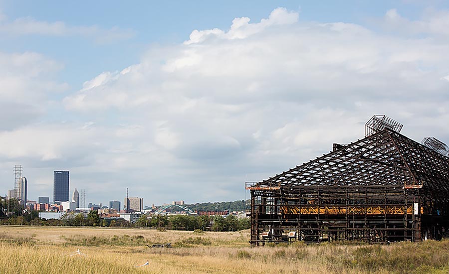
Image courtesy Annie O’Neill/Almono LLC
This spring, the Seattle-based landscape architecture firm GGN completed the two-acre Hazelwood Green Plaza in Pittsburgh. The small rectangular plaza, which features framed lawns, a flexible hardscape, and a tiered water feature, belies the outsize importance of the project, which sits along the Monongahela River.
The plaza is the heart of a 178-acre, 1.3-mile-long redevelopment project, which will restore access to the riverfront and transform a former steel-mill site and brownfield into a new center for light manufacturing, with public outdoor space and commercial, office, and residential opportunities.
“What drew us to this project was the significance of the site itself,” says GGN founding principal Jennifer Guthrie. “It was a chance to be part of the next generation of Pittsburgh.” The architects designed a sloping lawn that terminates to the north at Mill 19, which was built in 1943 and ultimately stored coke oven brick before its closure in the 1990s (right). Today, its original steel skeleton houses a mix of tenants, such as Carnegie Mellon University’s Manufacturing Futures Initiative (below).
Looking for quick answers on architecture and design topics?
Try Ask RECORD, our new smart AI search tool.
Ask RECORD →
For the plaza lawn, GGN created concrete steps and grassy berms that focus views toward the mill. Farther south, a water feature made of granite slabs has seat-height edges for relaxing; the water can be turned off for public programming.
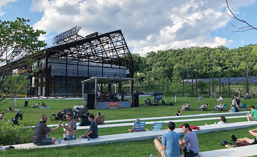
Image courtesy Hazelwood Local
Walls that run north–south along the plaza are made of reclaimed stone. GGN created a native-plant palette to set the tone for future development, as well a pollinator garden that will help with stormwater management. The landscape architects specifically selected trees for the size of their leaves, so they would act as an air-purification system.
The overall project required Guthrie’s team to use its imagination to envision a vibrant waterfront community where, as she says, there are currently “178 acres of emptiness.” Luckily, passionate advocates from the surrounding neighborhood had plenty of ideas for programming the plaza. “There was an incredible attitude of, ‘if you build it, they will come,’ ” says Guthrie.
GGN also looked for inspiration from the stakeholders’ mixed attitudes about Pittsburgh’s industrial past—older generations associated the former mill site with pollution, job loss, and disenfranchisement, while younger people tended to romanticize the mill’s former prowess.
“We wanted the plaza to feel as big and as monumental as a two-acre site could feel, to match the importance of the steel industry, for better or worse,” says Guthrie. “We look forward to watching the world come up around it.” Laura Raskin
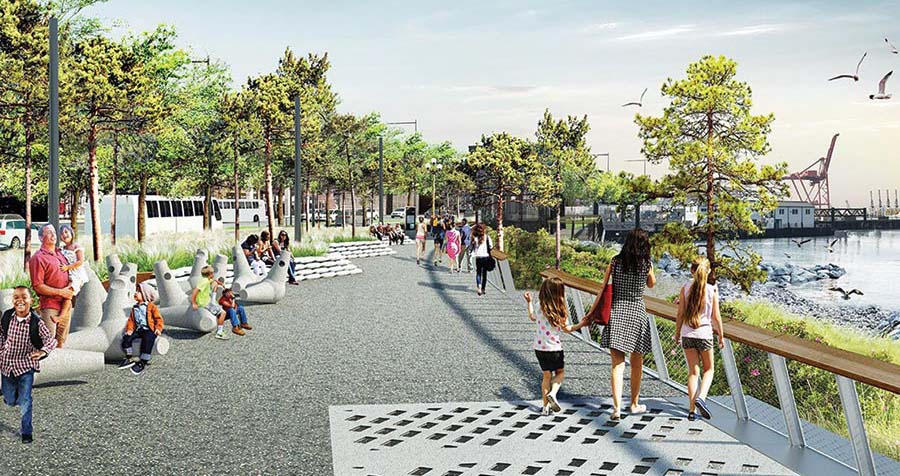
Seattle: Major changes on the waterfront
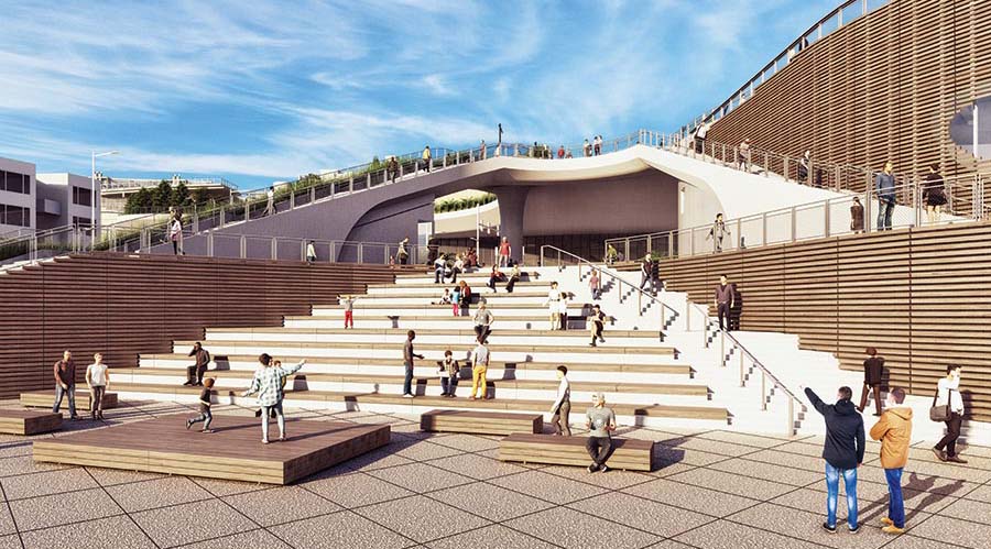
Image courtesy James Corner Field Operations
In 2010 James Corner and his landscape architecture firm Field Operations began to transform Seattle’s waterfront, which was blighted by the grim presence and constant din of a highway viaduct. In addition, the highway and the adjacent seawall at the edge of Elliott Bay were at a high seismic risk. In a series of expensive urban musical chairs, the seawall was replaced with a $410 million one calibrated with sea-level rise in mind. (Corner configured the underwater sections to appeal to migrating salmon and other species.) After a $4 billion, 200-foot-deep replacement highway tunnel was bored, demolition of the viaduct took place in 2019. Only then could construction begin in earnest on one of the most ambitious shoreline transformations in America, costing $781 million.
1. Image courtesy James Corner Field Operations
The 1.6-mile shoreline esplanade shifts local car and bus traffic inland to make room for a wide walkway along the seawall (1), where views of the bay alternate with commercial activity in preserved vaulted timber structures. Some piers along the way are being repurposed to host public events. In contrast to the prevailing hardscape of streets and skyscrapers, Corner introduces habitat strips of trees, native shrubs, and natural stormwater-management installations, intertwined with bike paths. He also interrupts the new seawall with “habitat beaches” that emulate predevelopment conditions. The combination juxtaposes the urban and the natural in surprising ways. The project includes art by native tribes and interpretive information about the history and culture of the people who nurtured this place before white settlers arrived. Tendrils of the park extend up the side streets, to draw people from this waterfront amenity to the canyon of skyscrapers just uphill.
The boldest element of the plan comes at the northern end, where a series of stairs, planted roofs, and ramps ascends a 110-foot-high bluff to link the waterfront to the famed Pike Place Market. It is an acrobatic architectural journey that begins in curving stairs (top) that wrap a new pavilion (designed by LMN) for the bayside aquarium. Called the Overlook Walk, its terraces offer ever-expanding views of Elliott Bay and the Olympic mountains.
The project, a welcome transformation for a downtown severely affected by Covid office and retail shutdowns, will open in stages and be fully complete before the end of 2024. James S. Russell, FAIA
L.A.: New facility recharges the ‘hood

Image courtesy Joshua White/JW Pictures
Robertson Recreation Center, completed by Kevin Daly Architects in December 2020, occupies a narrow wedge at the intersection of ethnically and socioeconomically contrasting communities. They include the Crestview neighborhood, more than 60 percent Hispanic or Black, as well as Beverlywood, an increasingly upper-middle-class Orthodox Jewish enclave. A Sikh temple and a Coptic Orthodox church are just across the street, with their followings nearby. “It’s a microcosm of contemporary L.A.,” says architect Kevin Daly, “and an example of the contested nature of the limited public space available in this city.”
The project replaces “Rob Rec,” a beloved mid-20th-century city Parks & Recreation facility that was dilapidated beyond repair. Its main space—a less than regulation-size basketball court—was vital to a largely underserved community. It produced such professional players as Nick Young, formerly of the L.A. Lakers and Golden State Warriors, and Cedric Ceballo, whose multi-team career also included the Lakers. But rebuilding was no simple matter—prior plans had been defeated by neighborhood opposition. And competing concerns persisted—whether or not racial undercurrents existed, the stated issues involved increased traffic, potential crime, protection of existing mature trees, and a desire for park, rather than parking, space.
Finally finished (top), the 12,000-square-foot, $11 million gymnasium-and-community center—spanning from busy Robertson Boulevard to quieter residential streets—navigates some of those issues while achieving a regulation-size indoor basketball court and a half-size outdoor one. Visually light, the undulant-walled metal-clad building—almost residentially scaled—bends around existing Melaleuca trees. Given the facility’s access to transit lines, parking was kept to a minimum. Also sustainable, the interior relies on daylight and natural ventilation. Though Covid restrictions have postponed the official opening, Young, who has championed both the old and new “Rob,” informally inaugurated the building by shooting the first basket. “And if they want me to host a youth basketball camp when it opens, I’m in,” he told Daly. “This was where it began for me.” S.A.
Buffalo: Banishing the highway for open space

Image courtesy CannonDesign
Since it was constructed in the early 1960s, the 3.6-mile Scajaquada Expressway has sliced through Buffalo’s Delaware Park, the crown jewel in a celebrated park system designed by Frederick Law Olmsted. The state highway, Route 198, replaced two tree-lined streets and was contested from the start. In addition to destroying Olmsted’s vision for the hourglass-shaped park, it segregated surrounding neighborhoods, especially communities of color. Traffic polluted the air and the adjacent Scajaquada Creek, creating adverse environmental and health effects. Then, in 2015, a vehicle traveling westbound on the highway killed a 3-year-old boy. The Department of Transportation responded with a plan to reduce speed limits and build medians, but the community roundly rejected it as simply not enough to counter 198’s deleterious effects.
Now momentum and consensus are building behind a plan to eliminate the highway altogether—a move that other U.S. cities, from Rochester to Detroit, have completed or considered. The Scajaquada Corridor Coalition (SCC), a diverse group of local organizations, is leading the call for removal, backed by renderings for the highway’s reenvisioning by CannonDesign’s Buffalo office. Two of its architects, Michael DeLuca and Mark Nowaczyk, sit on the SCC design committee and are passionate advocates for the plan. The renderings represent numerous improvements, including a widened and restored Scajaquada Creek; a reconnected Delaware Park; bike lanes and pedestrian paths; increased recreational space; and renewed connections between neighborhoods and job, commercial, education, and health-care centers.
The rendering (above, right) depicts SUNY Buffalo State College dorms and the creek. Students would have access to the waterfront and a pedestrian bridge connecting them to a local business district.
The Greater Buffalo-Niagara Regional Transportation Council is developing a final plan for the highway by March 2022. “We’re hopeful that this community dialogue will lead to a plan that is very similar to what we’ve shown,” says DeLuca.
Decreased speed limits and reduced traffic because of the pandemic have already improved the quality of life for area residents and provided a glimpse of what removal could mean. Also in the plan’s favor: $100 million of state funds have been allocated to the project, as well as federal infrastructure funds geared to removing highways that divide communities. L.R.
Looking for a reprint of this article?
From high-res PDFs to custom plaques, order your copy today!


